|
| Mesoscale Discussion 2152 |
|
< Previous MD Next MD >
|
|
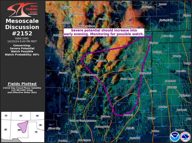
   Mesoscale Discussion 2152
   NWS Storm Prediction Center Norman OK
   0458 PM CDT Sun Oct 20 2024

   Areas affected...Eastern to north-central NM

   Concerning...Severe potential...Watch possible

   Valid 202158Z - 210000Z

   Probability of Watch Issuance...60 percent

   SUMMARY...The severe threat should increase into the early evening
   across parts of northern to eastern New Mexico. Large hail should be
   the main threat, but a tornado or two along with a localized severe
   gust is also possible. Uncertainty exists with the timing of greater
   than very isolated coverage, which impacts the expected peak
   intensity.

   DISCUSSION...Convection has gradually increased across mainly the
   north-central to northeast portion of NM, with a more recent
   increase over the past 30 min just east of the Sangre de Cristo
   Mountains. Other CU/small CB towers are widely spaced south into
   southeast NM as well. The environment, especially with southern
   extent where boundary-layer heating has been more pronounced, is
   conditionally favorable for supercells with strong effective bulk
   shear and mid/upper-level hodograph elongation. Recent HRRR guidance
   suggests initial activity should mainly pose a rather isolated large
   hail threat, with magnitude of 1-1.5 inch along the northern
   periphery of weak surface-based buoyancy. A more robust severe
   threat could develop towards 00-02Z if discrete supercells can
   become sustained farther south as a low-level jet intensifies from
   the Permian Basin northward. This could support a greater large hail
   and tornado threat during the early to mid-evening. But this
   potential increase may be short-lived, given onset of nocturnal
   cooling amid limited spatial extent of stronger heating west of the
   persistent stratocu deck still present over far east-central to
   northeast NM.

   ..Grams/Hart.. 10/20/2024

   ...Please see www.spc.noaa.gov for graphic product...

   ATTN...WFO...ABQ...

   LAT...LON   36050643 36350448 36610385 36770365 36780306 36150324
               35590349 34270375 33920381 33560418 33440462 33490494
               34040518 34730551 34950583 35400636 35780670 36050643
|
|
Top/All Mesoscale Discussions/Forecast Products/Home
|
|


 @NWSSPC