|
| Mesoscale Discussion 2150 |
|
< Previous MD Next MD >
|
|
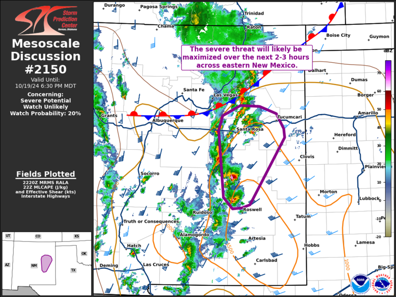
   Mesoscale Discussion 2150
   NWS Storm Prediction Center Norman OK
   0523 PM CDT Sat Oct 19 2024

   Areas affected...East-central New Mexico

   Concerning...Severe potential...Watch unlikely

   Valid 192223Z - 200030Z

   Probability of Watch Issuance...20 percent

   SUMMARY...The severe threat will likely be maximized across
   east-central New Mexico over the next 2-3 hours as supercells
   continue to mature within a supportive environment. Watch issuance
   is not expected given the relatively limited spatial/temporal extent
   of the threat.

   DISCUSSION...Over the past hour, several supercells across
   east-central NM have become much more intense and well-organized, as
   evident by robust hail signatures in MRMS data and three-body
   scatter spikes evident in KFDX imagery. In particular, two cells
   between the Fort Sumner and Roswell areas are currently moving
   across the most favorable thermodynamic environment, which is
   characterized by MLCAPE values between 1000-1500 J/kg per recent RAP
   mesoanalysis estimates. With 40-50 knots of effective bulk shear
   already in place across the warm sector, these two storms will
   likely remain discrete/semi-discrete supercells for the next couple
   of hours. Increasing low-level helicity after 00 UTC associated with
   a strengthening nocturnal jet may support some increase in tornado
   potential, but this may be conditional on whether storms remain in
   the viable surface-based warm sector, which is currently limited in
   northern extent by a residual stationary boundary north of the I-40
   corridor. Regardless, these cells will likely pose a severe hail
   (possibly up to 1.75 inches in diameter) and wind threat through at
   least 00-01 UTC.

   ..Moore/Guyer.. 10/19/2024

   ...Please see www.spc.noaa.gov for graphic product...

   ATTN...WFO...ABQ...

   LAT...LON   35300371 35010355 34840353 33540433 33480452 33470474
               33680495 34980507 35260497 35450456 35440411 35300371
|
|
Top/All Mesoscale Discussions/Forecast Products/Home
|
|


 @NWSSPC