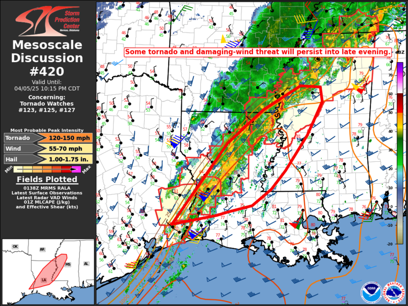
   Mesoscale Discussion 0420
   NWS Storm Prediction Center Norman OK
   0839 PM CDT Sat Apr 05 2025

   Areas affected...Extreme southeast TX into northern LA...western
   MS...and extreme southeast AR

   Concerning...Tornado Watch 123...125...127...

   Valid 060139Z - 060315Z

   The severe weather threat for Tornado Watch 123, 125, 127 continues.

   SUMMARY...Some tornado and damaging-wind threat will persist into
   late evening.

   DISCUSSION...Despite the presence of favorable buoyancy (with MLCAPE
   of 1500-2500 J/kg) and strong deep-layer shear, convection has
   struggled to organize this evening from the Sabine into the lower MS
   Valleys, likely due to warm temperatures aloft and very weak
   midlevel lapse rates, as observed on the 00Z JAN/LCH/LIX soundings.
   However, those soundings also depict rich boundary-layer moisture
   and strong low-level shear/SRH, resulting in a conditionally
   favorable tornadic supercell environment.

   It remains uncertain if any supercells can mature and stay
   along/ahead of an outflow-reinforced front into late evening.
   However, any increase in storm organization would result in a
   corresponding increase in the tornado and damaging-wind threat. Even
   if supercells struggle to mature, there will be some potential for
   one or more upscale-growing clusters to develop with time, which
   could pose an increasing threat of damaging wind. With the severe
   threat expected to develop east of the current watches with time,
   new watch issuance and/or local watch extension may eventually be
   needed.

   ..Dean/Hart.. 04/06/2025

   ...Please see www.spc.noaa.gov for graphic product...

   ATTN...WFO...JAN...LIX...LCH...SHV...

   LAT...LON   30149424 32229263 33079156 33679043 33648982 33278977
               32429025 31529090 31069132 30639190 30489259 30389292
               30149424

   MOST PROBABLE PEAK TORNADO INTENSITY...120-150 MPH
   MOST PROBABLE PEAK WIND GUST...55-70 MPH
   MOST PROBABLE PEAK HAIL SIZE...1.00-1.75 IN
|


 @NWSSPC