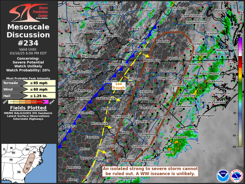
   Mesoscale Discussion 0234
   NWS Storm Prediction Center Norman OK
   0325 PM CDT Sun Mar 16 2025

   Areas affected...portions of southern Virginia to the South Carolina
   and Georgia border

   Concerning...Severe potential...Watch unlikely

   Valid 162025Z - 162200Z

   Probability of Watch Issuance...20 percent

   SUMMARY...An isolated severe threat could materialize with any
   storms that manage to develop ahead of the lee trough and cold
   front, behind earlier storms. Given the sparse severe threat, a WW
   issuance is not expected.

   DISCUSSION...Earlier day showers and thunderstorms (which posed a
   severe threat) have generally cleared much of the east-central
   CONUS. However, ample diurnal heating is occurring behind these
   storms, in advance of an eastward drifting lee trough and surface
   cold front. Surface temperatures are exceeding 75 F in some spots,
   with dewpoints in the mid 50s to 60s F ahead of the lee trough,
   boosting low-level lapse rates to 8 C/km and MLCAPE to 500-1000
   J/kg. Deep-layer ascent continues to drift away from the lee of the
   Appalachians, reducing the chances for thunderstorm redevelopment.
   However, with 50-80 kts of effective bulk shear overspreading this
   modified airmass, any thunderstorm that manages to develop and
   become sustained may produce strong wind gusts and perhaps some
   hail. Given the expected isolated nature of the severe threat, a WW
   issuance is not expected.

   ..Squitieri/Gleason.. 03/16/2025

   ...Please see www.spc.noaa.gov for graphic product...

   ATTN...WFO...AKQ...LWX...RAH...ILM...RNK...CHS...CAE...GSP...

   LAT...LON   32918209 34348150 36928021 37447995 37707947 37737863
               37417822 37097802 36697813 34587931 33168019 32498097
               32498160 32638173 32918209
|


 @NWSSPC