|
| Mesoscale Discussion 225 |
|
< Previous MD Next MD >
|
|
Mesoscale Discussion 0225
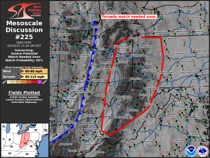
NWS Storm Prediction Center Norman OK
0904 AM CDT Sun Mar 16 2025
Areas affected...eastern Ohio...much of West Virginia...and western
Pennsylvania
Concerning...Severe potential...Watch needed soon
Valid 161404Z - 161530Z
Probability of Watch Issuance...95 percent
SUMMARY...A tornado watch is needed soon across eastern Ohio,
western Pennsylvania, and much of West Virginia.
DISCUSSION...An area of clearing has developed across eastern Ohio,
West Virginia, and western Pennsylvania this morning. This clearing
should permit a period of solar insolation which will destabilize
much of the region by late morning. Minimal inhibition was present
on the 12Z RAOBs from PIT and ILN. Therefore, only minimal heating
should be required for a line of storms to develop. A very strong
wind profile across the region will support organized storms and
provide ambient synoptic flow which can easily mix damaging winds to
the surface within any convection. In addition, low-level shear is
very strong with over 450 m2/s2 0-1km SRH (per PBZ VWP). Damaging
wind gusts are the primary concern from the fast moving squall line
which is expected to develop. However, given the strong shear, some
line-embedded tornadoes will also be possible.
Initially, a line of storms will likely develop where some lightning
has already occurred within a pre-frontal trough feature across
eastern Ohio and into western West Virginia with an additional line
of storms expected along the cold front which is currently moving
through central Ohio and central Kentucky. Eventually expect the
line of storms along the cold front to become the dominant squall
line by this afternoon as these storms advance east.
..Bentley/Gleason.. 03/16/2025
...Please see www.spc.noaa.gov for graphic product...
ATTN...WFO...CTP...LWX...PBZ...RLX...CLE...
LAT...LON 38677985 37628173 37838228 38438220 39688203 41058162
41758140 41918087 41968051 41957955 41947884 41447877
41037870 40177889 38957953 38677985
|
|
Top/All Mesoscale Discussions/Forecast Products/Home
|
|


 @NWSSPC