|
| Mesoscale Discussion 219 |
|
< Previous MD Next MD >
|
|
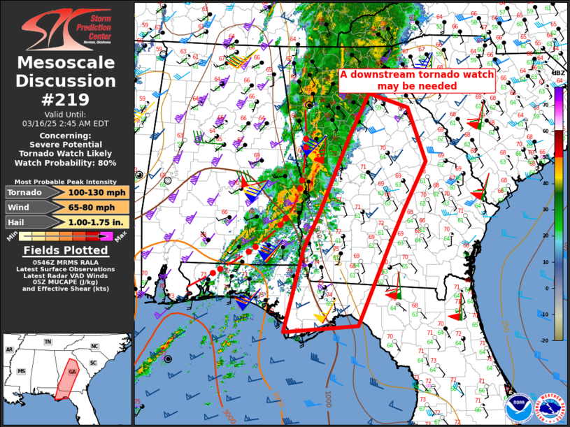
   Mesoscale Discussion 0219
   NWS Storm Prediction Center Norman OK
   1247 AM CDT Sun Mar 16 2025

   Areas affected...Central/southwest Georgia and the eastern Florida
   Panhandle

   Concerning...Severe potential...Tornado Watch likely

   Valid 160547Z - 160645Z

   Probability of Watch Issuance...80 percent

   SUMMARY...Gradual destabilization will support a continued threat of
   wind damage and a few tornadoes into central/southwest GA and the
   eastern FL Panhandle through early morning.  A new tornado may be
   needed after 06z.

   DISCUSSION...A band of storms with embedded bow/supercell
   characteristics is moving east-northeastward into west central GA,
   with continued storm development farther southwest along a
   confluence zone across southeast AL.  The storms are along the
   eastern edge of the richer low-level moisture, but a 70 kt low-level
   jet will result in sufficient moisture transport near/just above the
   surface to maintain the convection for the next several hours.
   Given the very strong low-level shear/large hodographs, the
   potential for occasional wind damage and embedded
   circulations/tornadoes will persist.  Thus, a new tornado watch will
   likely be needed into central/southwest GA and the eastern FL
   Panhandle after 06z.

   ..Thompson/Smith.. 03/16/2025

   ...Please see www.spc.noaa.gov for graphic product...

   ATTN...WFO...JAX...FFC...TAE...

   LAT...LON   33318405 34148361 33888277 32888240 32038286 31438316
               29898384 29788541 31298501 31928468 33318405
|
|
Top/All Mesoscale Discussions/Forecast Products/Home
|
|


 @NWSSPC