|
| Mesoscale Discussion 214 |
|
< Previous MD Next MD >
|
|
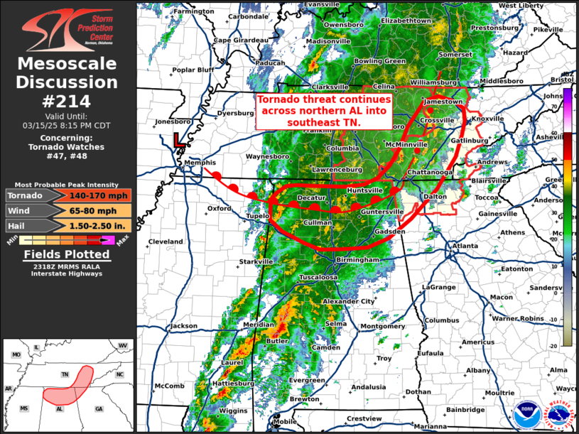
   Mesoscale Discussion 0214
   NWS Storm Prediction Center Norman OK
   0621 PM CDT Sat Mar 15 2025

   Areas affected...Northern Alabama into eastern Tennessee

   Concerning...Tornado Watch 47...48...

   Valid 152321Z - 160115Z

   The severe weather threat for Tornado Watch 47, 48 continues.

   SUMMARY...The threat for tornadoes and severe gusts continues across
   northern Alabama into eastern Tennessee for the next few hours.

   DISCUSSION...Over the past 1-2 hours, convection across
   north-central AL has struggled to maintain intensity as it migrates
   into a deeply saturated, rain cooled environment. Recent surface
   observations depict a rather pronounced surface warm front extending
   across northern AL that delineates the northern extent of
   appreciable surface-based buoyancy. Despite the thermodynamic
   challenges, the low to mid-level theta-e axis remains in place
   across north-central AL. Strong isentropic ascent within this regime
   continues to support very strongly veered hodographs within the
   lowest few kilometers, exemplified by KBMX and KHTX VWP observations
   featuring 0-1 km SRH on the order of 400-500 m2/s2. Additionally,
   GOES IR imagery and lightning data have shown occasional updraft
   pulses within this warm advection regime and embedded supercell
   structures within a broken line of storms across eastern Middle TN
   which hint that buoyancy remains adequate for at least transient
   deep convection. Recent WoFS guidance appears to support this idea
   with some signal for low-level helicity tracks and severe gust
   potential focused across northeast AL into eastern/southeastern TN
   between 23-02 UTC.

   ..Moore.. 03/15/2025

   ...Please see www.spc.noaa.gov for graphic product...

   ATTN...WFO...MRX...FFC...OHX...BMX...HUN...MEG...

   LAT...LON   36448458 36358426 36238405 36008403 35768410 35398424
               34828464 34328519 33988567 33828612 33788666 33788710
               33898744 34098791 34288816 34648816 34758804 34888784
               34908761 34888726 34878657 34928619 35038590 35248565
               35548543 35928525 36378488 36448458
|
|
Top/All Mesoscale Discussions/Forecast Products/Home
|
|


 @NWSSPC