|
| Mesoscale Discussion 208 |
|
< Previous MD Next MD >
|
|
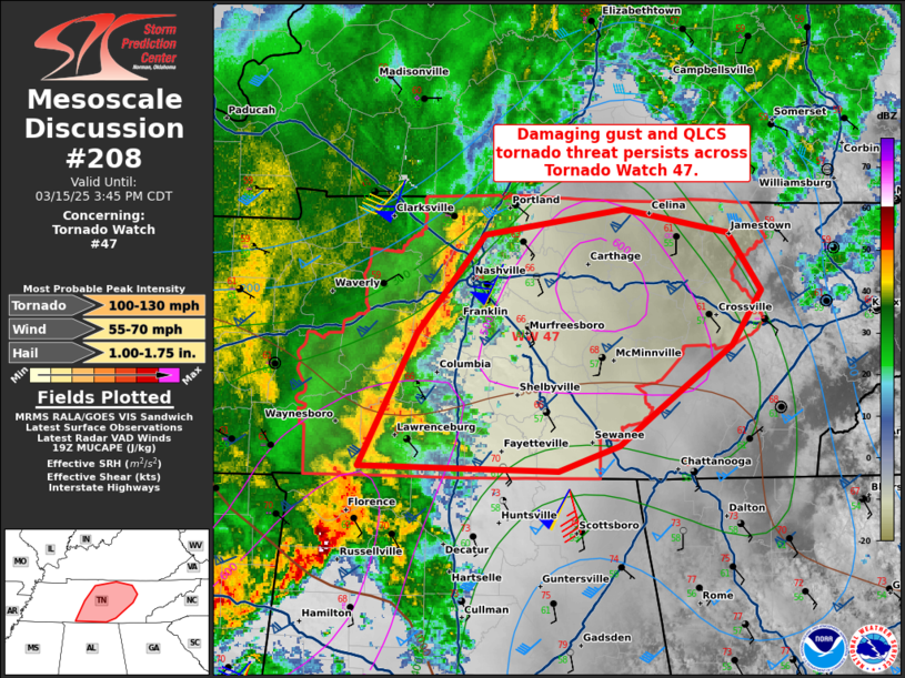
   Mesoscale Discussion 0208
   NWS Storm Prediction Center Norman OK
   0215 PM CDT Sat Mar 15 2025

   Areas affected...portions of middle Tennessee

   Concerning...Tornado Watch 47...

   Valid 151915Z - 152045Z

   The severe weather threat for Tornado Watch 47 continues.

   SUMMARY...The severe threat continues across Tornado Watch 47. A few
   damaging gusts or QLCS tornadoes remain possible.

   DISCUSSION...A QLCS continues to progress eastward across Middle TN
   amid afternoon peak heating. Surface temperatures have warmed to
   over 70 F downstream of the QLCS, supporting MUCAPE approaching 500
   J/kg. Though the HTX VAD shows a large, curved hodograph,
   boundary-layer buoyancy remains scant (as demonstrated by neutral to
   stable lapse-rates in the 18Z BNA observed sounding). As such, it is
   unclear how much of the ambient environmental SRH is effective (i.e.
   can be ingested into the leading-line updrafts). At least a threat
   for damaging gusts should persist with the progression of this line,
   though a few tornadoes remain possible given such strong low-level
   shear.

   ..Squitieri.. 03/15/2025

   ...Please see www.spc.noaa.gov for graphic product...

   ATTN...WFO...MRX...OHX...HUN...

   LAT...LON   35058759 35848718 36428668 36578568 36428494 36088470
               35778491 35398543 35188571 35028616 35058759
|
|
Top/All Mesoscale Discussions/Forecast Products/Home
|
|


 @NWSSPC