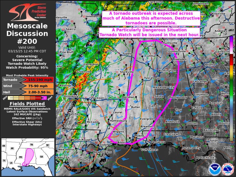
   Mesoscale Discussion 0200
   NWS Storm Prediction Center Norman OK
   1119 AM CDT Sat Mar 15 2025

   Areas affected...extreme southeast Mississippi into much of western
   and central Alabama

   Concerning...Severe potential...Tornado Watch likely

   Valid 151619Z - 151745Z

   Probability of Watch Issuance...95 percent

   SUMMARY...The severe threat will increase through the afternoon,
   including the potential for multiple intense, destructive tornadoes.
   A Particularly Dangerous Situation Tornado Watch will be issued in
   the next hour.

   DISCUSSION...Thunderstorms, including supercells, continue to
   increase in coverage and intensity over in MS with the rapid
   approach of a potent mid-level trough. A pronounced 500 mb speed max
   will glance the region to the west, promoting the maintenance of
   ongoing storms, while also contributing to adequate deep-layer
   ascent for the development of new supercells in warm-sector
   confluence bands. As this occurs, these supercells will mature in a
   moistening low-level airmass, with dewpoints in the mid 60s F,
   overspread by 8 C/km mid-level lapse rates. MLCAPE should reach
   around 2000 J/kg amid 400+ m2/s2 effective SRH (driven by large,
   elongated/curved hodographs that are already evident via regional
   VADs). The anticipated parameter space will be highly supportive of
   tornadic supercells. The more discrete, dominant supercell
   structures will be capable of intense, destructive tornadoes, and
   violent tornadoes cannot be ruled out. A severe hail/wind threat
   should also accompany any robust, sustained thunderstorms. A
   Particularly Dangerous Situation Tornado Watch will be needed in the
   next hour to address the impending severe threat.

   ..Squitieri/Gleason.. 03/15/2025

   ...Please see www.spc.noaa.gov for graphic product...

   ATTN...WFO...BMX...HUN...MOB...LIX...

   LAT...LON   31468689 30738738 30418812 30488903 30678929 31118899
               31568843 32138842 34508792 34888771 34938686 34598605
               33918572 33108579 32258622 31468689
|


 @NWSSPC