|
| Mesoscale Discussion 197 |
|
< Previous MD Next MD >
|
|
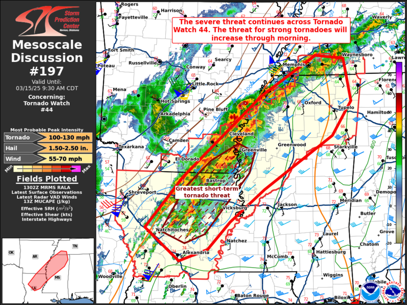
   Mesoscale Discussion 0197
   NWS Storm Prediction Center Norman OK
   0804 AM CDT Sat Mar 15 2025

   Areas affected...portions of central Louisiana into northern
   Mississippi and extreme southwestern Tennessee

   Concerning...Tornado Watch 44...

   Valid 151304Z - 151430Z

   The severe weather threat for Tornado Watch 44 continues.

   SUMMARY...The severe threat continues across Tornado Watch 44. The
   potential for tornadoes (some strong) will only increase into the
   morning hours. Severe wind and hail will also be possible.

   DISCUSSION...Deep-moist convection continues to increase in coverage
   and intensity along a baroclinic zone characterizing the
   northwestern bounds of the free warm sector. Recently, storms along
   the southern extent of this convective band have developed supercell
   characteristics, with pronounced low-level mesocyclones noted via
   KSHV radar data. 12Z JAN and LCH soundings show mid-level lapse
   rates above 8.5 C/km, along with rich low-level moisture and large,
   curved/elongated hodographs already in place, which is highly
   supportive of tornadic supercells. Through the morning hours,
   increased boundary-layer heating and ascent from the approaching
   upper trough should only boost shear/buoyancy further, resulting in
   a continued increasing severe threat. All severe hazards will be
   possible, including strong tornadoes, particularly with the more
   sustained supercells with unimpeded inflow.

   ..Squitieri.. 03/15/2025

   ...Please see www.spc.noaa.gov for graphic product...

   ATTN...WFO...MEG...JAN...LZK...LCH...SHV...

   LAT...LON   31879333 32919243 34569055 35398920 35328852 34458835
               33768881 32679047 32019130 31449182 31209250 31879333
|
|
Top/All Mesoscale Discussions/Forecast Products/Home
|
|


 @NWSSPC