|
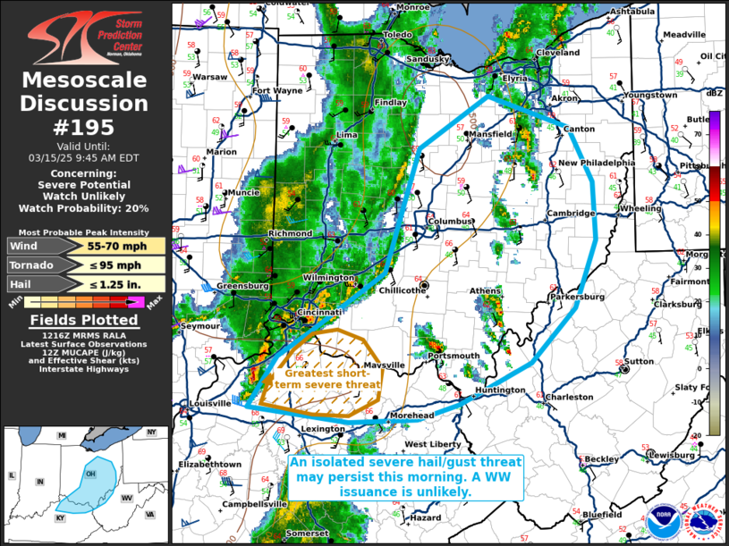
| Mesoscale Discussion 195 |
|
< Previous MD Next MD >
|
|
   Mesoscale Discussion 0195
   NWS Storm Prediction Center Norman OK
   0719 AM CDT Sat Mar 15 2025

   Areas affected...portions of northeastern Kentucky...southern and
   central Ohio...and extreme western West Virginia

   Concerning...Severe potential...Watch unlikely

   Valid 151219Z - 151345Z

   Probability of Watch Issuance...20 percent

   SUMMARY...A few instances of severe hail or damaging gusts may
   continue for a few more hours. The overall severe threat appears
   isolated and a downstream WW issuance is not currently anticipated.

   DISCUSSION...A line of thunderstorms with a history of severe hail
   and damaging gusts (some of which have exceeded severe limits)
   continues to progress eastward as a stacked cyclone over the Great
   Lakes continues to track toward Ontario. This line of storms
   (especially the southern portion) continues to effectively transport
   stronger flow aloft to the surface, with 7-8 C/km mid-level lapse
   rates likely supporting continuing severe hail production. However,
   this line of storms is approaching the eastern bounds of what is
   already scant buoyancy (characterized by 200 J/kg MUCAPE per the 12Z
   ILN observed sounding), and this line should gradually outpace this
   marginal instability with time. As such, the severe threat should
   generally remain limited, though a focused severe threat may
   continue with the more robust storms (southern portion of the line
   in KY) for at least a few more hours.

   ..Squitieri/Smith.. 03/15/2025

   ...Please see www.spc.noaa.gov for graphic product...

   ATTN...WFO...PBZ...RLX...CLE...JKL...ILN...LMK...

   LAT...LON   38308507 38478495 38768472 38988435 39538348 40688308
               41158225 40868130 40378101 39848099 39218124 38728176
               38348260 38208308 38178389 38308507
|
|
Top/All Mesoscale Discussions/Forecast Products/Home
|
|


 @NWSSPC