|
| Mesoscale Discussion 188 |
|
< Previous MD Next MD >
|
|
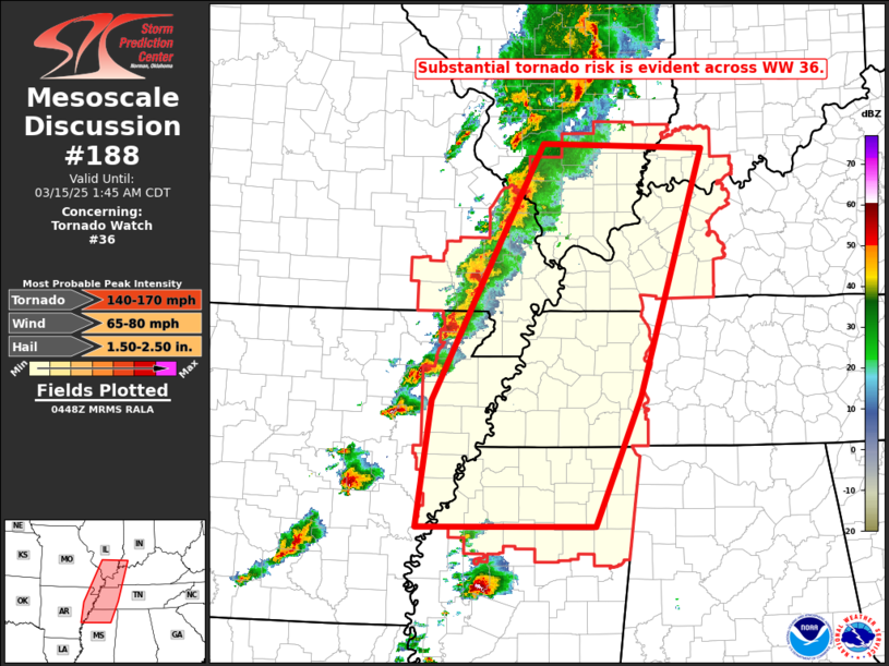
   Mesoscale Discussion 0188
   NWS Storm Prediction Center Norman OK
   1150 PM CDT Fri Mar 14 2025

   Areas affected...southern Illinois...southwestern
   Indiana...southeastern Missouri...western Kentucky...western
   Tennessee...eastern Arkansas...and northern Mississippi

   Concerning...Tornado Watch 36...

   Valid 150450Z - 150645Z

   The severe weather threat for Tornado Watch 36 continues.

   SUMMARY...Severe/tornado risk is spreading eastward into Tornado
   Watch 36.  A few strong tornadoes are possible.

   DISCUSSION...Latest radar loop shows a broken band comprised of
   numerous supercell storms, extending from southern
   Illinois/southeastern Missouri southwestward into southwestern
   Arkansas.  Sustained rotational signatures have persisted with
   several of these storms, as they move through an axis of 1500 to
   2500 J/kg mixed-layer CAPE and surface dewpoints generally in the
   upper 50s across this area.

   With very strong flow present across the region, that veers with
   height, these kinematically favorable conditions suggest
   continuation of the tornado risk as storms move through the
   instability axis ahead of the surface front.  A few of the tornadoes
   could be strong/potentially significant over the next few hours, as
   they spread eastward toward/across the Mississippi River.

   ..Goss.. 03/15/2025

   ...Please see www.spc.noaa.gov for graphic product...

   ATTN...WFO...OHX...PAH...MEG...JAN...LSX...LZK...

   LAT...LON   34109110 35509090 38368940 38298720 35548806 34118869
               34109110
|
|
Top/All Mesoscale Discussions/Forecast Products/Home
|
|


 @NWSSPC