|
| Mesoscale Discussion 140 |
|
< Previous MD Next MD >
|
|
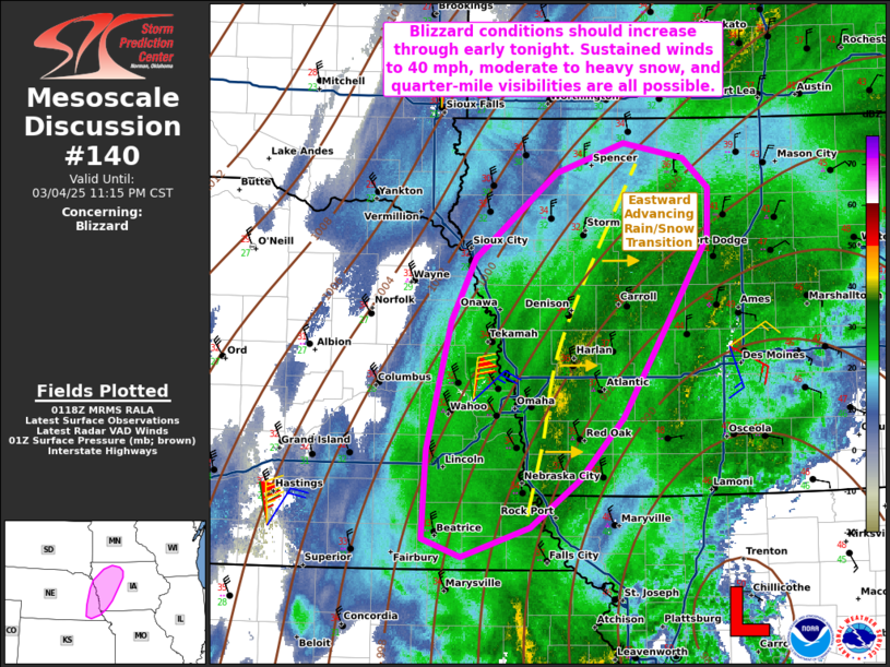
   Mesoscale Discussion 0140
   NWS Storm Prediction Center Norman OK
   0720 PM CST Tue Mar 04 2025

   Areas affected...portions of extreme eastern Nebraska into western
   Iowa

   Concerning...Blizzard

   Valid 050120Z - 050515Z

   SUMMARY...Blizzard conditions are expected to become more common
   through early tonight. Sustained winds over 40 mph are possible amid
   intermittent bouts of moderate to heavy snow and quarter-mile
   visibilities.

   DISCUSSION...A surface low, analyzed just east-northeast of the
   Kansas City metropolitan area, continues to drift northeast while
   gradually deepening. The northwest quadrant of this low continues to
   overspread portions of extreme eastern NE into western IA, where
   deep-layer cold-air advection is supporting the transition from rain
   to snow. Surface observations and correlation coefficient data from
   KOAX NEXRAD radar indicate the rain/snow transition line roughly
   from Crawford to Fremont Counties in IA, with surface northwesterly
   winds intensifying to over 30 kts west of this line. The expectation
   is for sustained surface winds to reach 40 mph in spots, with
   increasing snowfall rates (perhaps briefly reaching 1 inch/hour)
   over the next few hours. Such conditions may reduce visibility to
   around a quarter mile or less. Additionally, the latest
   high-resolution guidance consensus suggests that blizzard conditions
   are most likely across western IA in the 02-08Z time frame.

   ..Squitieri.. 03/05/2025

   ...Please see www.spc.noaa.gov for graphic product...

   ATTN...WFO...DMX...EAX...FSD...OAX...

   LAT...LON   40249688 40929684 41939659 42419633 43079549 43309480
               43189418 42959391 42589392 41989430 41179480 40699525
               40339576 40109647 40249688
|
|
Top/All Mesoscale Discussions/Forecast Products/Home
|
|


 @NWSSPC