|
| Mesoscale Discussion 117 |
|
< Previous MD Next MD >
|
|
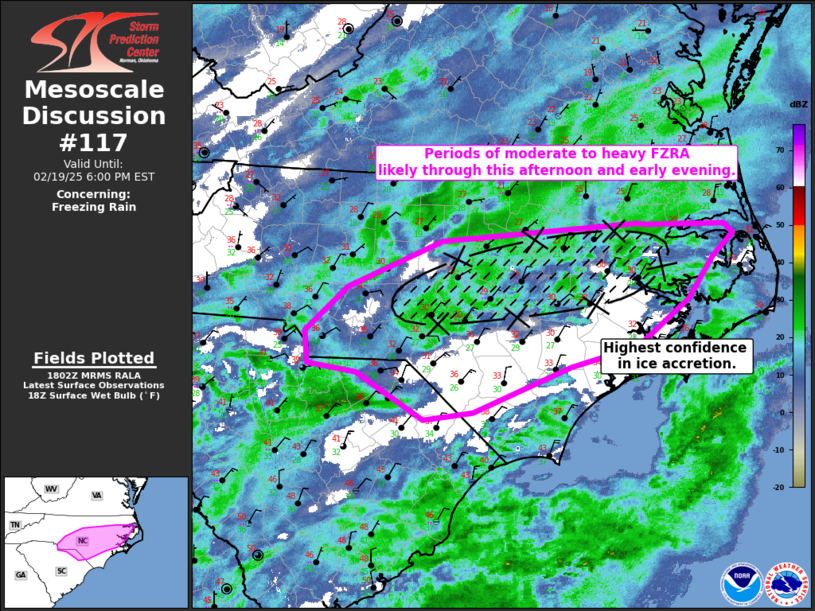
   Mesoscale Discussion 0117
   NWS Storm Prediction Center Norman OK
   1204 PM CST Wed Feb 19 2025

   Areas affected...portions of North and South Carolina

   Concerning...Freezing rain

   Valid 191804Z - 192300Z

   SUMMARY...Freezing rain with rates of 0.05-0.1 in/hr appear likely
   over parts of the Carolinas through much of this afternoon into the
   evening hours. Ice accretion and impacts are most likely over parts
   of central and eastern NC.

   DISCUSSION...Early afternoon surface observations and regional radar
   show a broad mosaic of wintry precipitation interacting with a
   shallow cold air mass across parts of the Carolinas. Over the last
   hour, several observing sites across central and eastern NC have
   shown an increase in freezing rain rates and ice accretion, as
   precipitation has expanded in coverage and intensity. SPC
   mesoanalysis shows near-freezing surface wet bulb temperatures are
   gradually expanding southwestward into portions of central and
   southern NC and the border of SC. Likely tied to stronger low-level
   cold advection within the cold air damming regime east of the higher
   terrain, surface temperatures are expected to steadily fall below
   freezing through this afternoon. At the same time, weak warm air
   advection (950-800 mb layer) and increasing deep-layer ascent from
   an upstream trough will support greater coverage of moderate to
   locally heavy stratiform precipitation from western SC/NC eastward.
   With temperatures of 0.5-2C within the warm layer aloft, freezing
   rain appears to be the primary precipitation type. However, a mix of
   sleet and snow will remain possible as colder air deepens gradually
   from the north. Area RAP/HRRR soundings and observed trends suggest
   freezing rain rates of 0.05-0.1 in/hr are possible. Confidence in
   significant accretion/impacts is highest over portions of central
   and eastern NC where surface temperatures are cooler (mid to upper
   20s F) and locally heavier precipitation is expected.

   ..Lyons.. 02/19/2025

   ...Please see www.spc.noaa.gov for graphic product...

   ATTN...WFO...AKQ...MHX...RAH...ILM...CAE...GSP...

   LAT...LON   34698024 34768079 35068082 35478034 35907926 36077705
               36067694 36057607 35977597 35757619 35377647 34937706
               34747782 34327892 34247948 34698024
|
|
Top/All Mesoscale Discussions/Forecast Products/Home
|
|


 @NWSSPC