|
| Mesoscale Discussion 111 |
|
< Previous MD
|
|
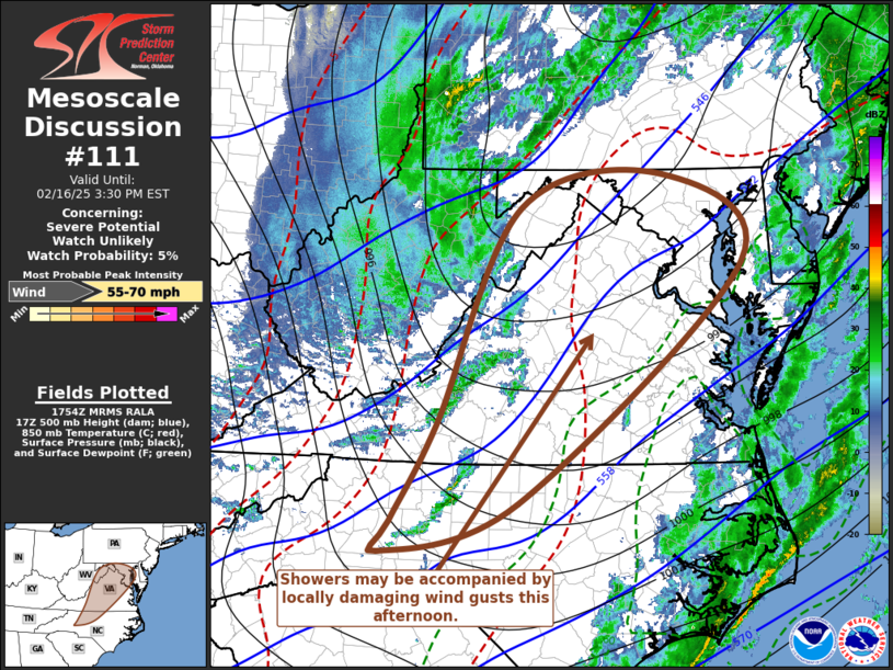
   Mesoscale Discussion 0111
   NWS Storm Prediction Center Norman OK
   1155 AM CST Sun Feb 16 2025

   Areas affected...parts of southwestern through north central
   Virginia and adjacent portions of the Mid Atlantic

   Concerning...Severe potential...Watch unlikely

   Valid 161755Z - 162030Z

   Probability of Watch Issuance...5 percent

   SUMMARY...Locally damaging wind gusts may accompany showers
   spreading east-northeast of the Blue Ridge, across the Mid Atlantic,
   this afternoon.

   DISCUSSION...Beneath the leading edge of mid-level forcing for
   ascent and cooling (generally in the 850-500 mb layer) spreading
   across and east of the Allegheny and Blue Ridge Mountains,
   insolation is contributing to modest steepening of lapse rates and
   destabilization sufficient for low-topped convective development.
   As this spreads east-northeastward toward the coastal plain through
   3-5 PM EDT, it remains unclear whether this will deepen through
   sufficiently cold layers aloft to support an appreciable risk for
   thunderstorms.

   However, to the south of a large and still deepening cyclone,
   activity is embedded within strong southwesterly to westerly
   deep-layer mean wind fields, which still appears to include 50-60 kt
   in the lowest 3 km AGL.  Although a relatively cool and moist
   near-surface environment may not be particularly efficient
   contributing to the downward mixing of momentum, heavier
   precipitation in the stronger convection may still support
   occasional potentially damaging gusts reaching the surface.

   ..Kerr/Smith.. 02/16/2025

   ...Please see www.spc.noaa.gov for graphic product...

   ATTN...WFO...PHI...AKQ...LWX...RAH...RNK...GSP...

   LAT...LON   39307913 39667718 38727610 36117916 35598103 35918088
               36978026 39307913
|
|
Top/All Mesoscale Discussions/Forecast Products/Home
|
|


 @NWSSPC