|
| Mesoscale Discussion 109 |
|
< Previous MD Next MD >
|
|
Mesoscale Discussion 0109
NWS Storm Prediction Center Norman OK
0728 AM CST Sun Feb 16 2025
Areas affected...Northern New York...Northern New England
Concerning...Winter mixed precipitation
Valid 161328Z - 161930Z
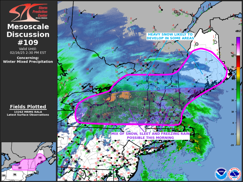
SUMMARY...Heavy snow will likely develop across parts of northern
New York and northern New England this morning. Further south into
parts of east-central New York and central New England, a mix of
snow, sleet and freezing rain will be possible this morning.
DISCUSSION...A mid-level trough will quickly move through the
southern and central Appalachians this morning. A surface low will
deepen and move northeastward into the Northeast. Ahead of the
system, a band of strong warm-advection was located from New York
eastward into the southern New England, where widespread
precipitation is ongoing. The freezing line is currently located
from southern New York eastward into southern New England. A zone
(about 100 miles wide) of freezing rain and sleet is located to the
north of the freezing line. This freezing rain and sleet will spread
northward over the next few hours. A changeover to rain will occur
as the freezing line moves northward. In addition, areas that are
experiencing snow may changeover to freezing rain. Freezing rain
rates could exceed 0.05 inches per hour.
Further north into northern New England, surface temperatures are in
the teens and single digits. The cold air in the low to mid-levels
will make snow the primary precipitation type. As strong warm
advection and isentropic lift increase across the region, the
development of heavy snow will likely occur in many areas. Snowfall
rates could exceed 1 inch per hour.
..Broyles.. 02/16/2025
...Please see www.spc.noaa.gov for graphic product...
ATTN...WFO...CAR...GYX...BOX...BTV...ALY...BGM...BUF...
LAT...LON 43197054 42797083 42357095 42227144 42257364 42237611
42237809 42297855 42527872 42797875 43207863 43387841
43667772 43957661 44097625 44377600 44717549 44937500
44987440 44997194 45087130 45287091 45867027 46206992
46346945 46366911 46216857 46036820 45266735 44906732
44666748 44396787 44166854 43756959 43407029 43197054
|
|
Top/All Mesoscale Discussions/Forecast Products/Home
|
|


 @NWSSPC