|
| Mesoscale Discussion 107 |
|
< Previous MD Next MD >
|
|
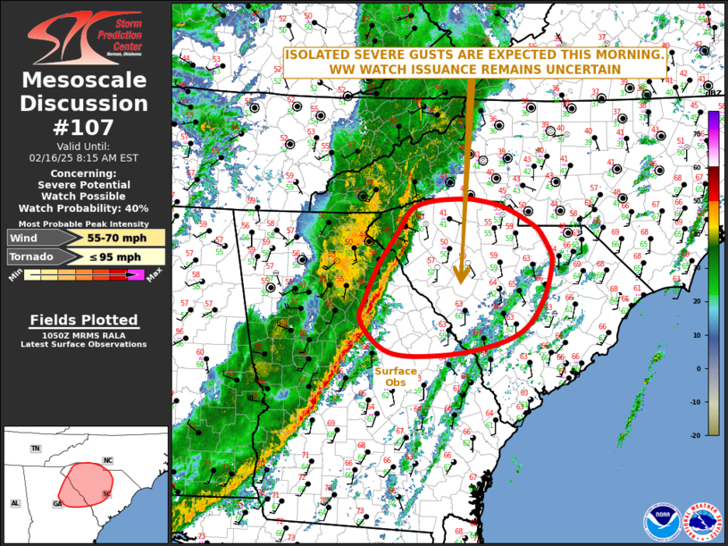
   Mesoscale Discussion 0107
   NWS Storm Prediction Center Norman OK
   0452 AM CST Sun Feb 16 2025

   Areas affected...Northeast Georgia...South Carolina

   Concerning...Severe potential...Watch possible

   Valid 161052Z - 161315Z

   Probability of Watch Issuance...40 percent

   SUMMARY...Isolated severe gusts are expected this morning across
   parts western and central South Carolina. Weather watch issuance
   remains uncertain.

   DISCUSSION...Mosaic radar imagery currently shows a squall line
   across parts of central Georgia extending northeastward into far
   western South Carolina. The line is being supported by strong
   large-scale ascent associated with an approaching trough, and by
   forcing along a fast-moving cold front. Ahead of the line,
   instability is very weak, with surface dewpoints in the 50s F across
   western South Carolina and northeast Georgia. The latest WSR-88D VWP
   at Greenville/Spartanburg has about 85 knot of 0-6 km shear with 40
   to 50 knots of south-southwesterly flow located just above the
   surface. An isolated wind-damage threat will be possible with the
   stronger cells within the line. Given the very strong low-level
   shear, meso-scale vorticies will be possible in the line with
   embedded cells that remain surface-based. However, forecast
   soundings in far western South Carolina have a sharp near surface
   temperature inversion, which should keep any severe threat isolated
   and localized.

   ..Broyles/Gleason.. 02/16/2025

   ...Please see www.spc.noaa.gov for graphic product...

   ATTN...WFO...ILM...CHS...CAE...GSP...FFC...

   LAT...LON   35208161 35168219 35048258 34768279 34268314 33768337
               33478343 33058296 33018208 33158120 33408066 33838035
               34298023 34458026 34728042 34848055 35088106 35208161
               35208161
|
|
Top/All Mesoscale Discussions/Forecast Products/Home
|
|


 @NWSSPC