|
| Mesoscale Discussion 82 |
|
< Previous MD Next MD >
|
|
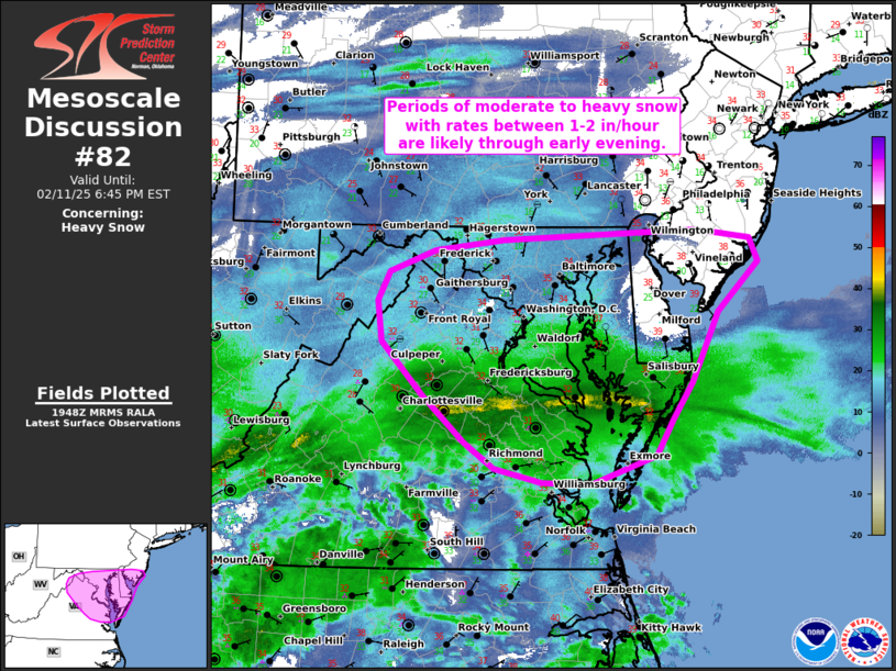
   Mesoscale Discussion 0082
   NWS Storm Prediction Center Norman OK
   0149 PM CST Tue Feb 11 2025

   Areas affected...parts of the Mid-Atlantic

   Concerning...Heavy snow

   Valid 111949Z - 112345Z

   SUMMARY...A band of heavy snow developing across the Mid-Atlantic
   region will be capable of moderate to heavy snowfall rates upwards
   of 1-2 inches per hour. Similar bands and snowfall rates will be
   possible through early evening.

   DISCUSSION...Regional radar imagery shows an organized
   precipitation/snow band developing from west-central VA into the
   Chesapeake Bay area. Recent snowfall reports from central VA and
   surface observations reporting visibility reductions between 0.25 to
   0.5 mile suggest moderate to heavy snowfall rates are ongoing. This
   band is largely being driven by a combination of strong warm-air
   advection and frontogenesis within the 925-700 mb layer and may
   persist for another hour or two given the strength of forcing for
   ascent. Additional banding is possible heading into the late
   afternoon hours as a weak mid-level impulse - and the primary
   precipitation shield - migrates into the region and to the
   north/northeast into northern MD and DE. Recent guidance suggests
   heavy snow potential will likely peak across the Chesapeake Bay area
   during the 21-00 UTC period. Although surface temperatures across
   this region remain near/above freezing, dewpoints in the 20s suggest
   that temperatures will likely fall to below freezing due to
   low-level evaporative cooling associated with the onset of
   precipitation, which should support heavier snowfall rates later
   this afternoon.

   ..Moore.. 02/11/2025

   ...Please see www.spc.noaa.gov for graphic product...

   ATTN...WFO...PHI...AKQ...LWX...

   LAT...LON   39697503 39597727 39497808 39297861 39027876 38647871
               38157822 37727772 37477737 37357681 37327624 37597546
               37947527 38287504 38927472 39397424 39607435 39667473
               39697503
|
|
Top/All Mesoscale Discussions/Forecast Products/Home
|
|


 @NWSSPC