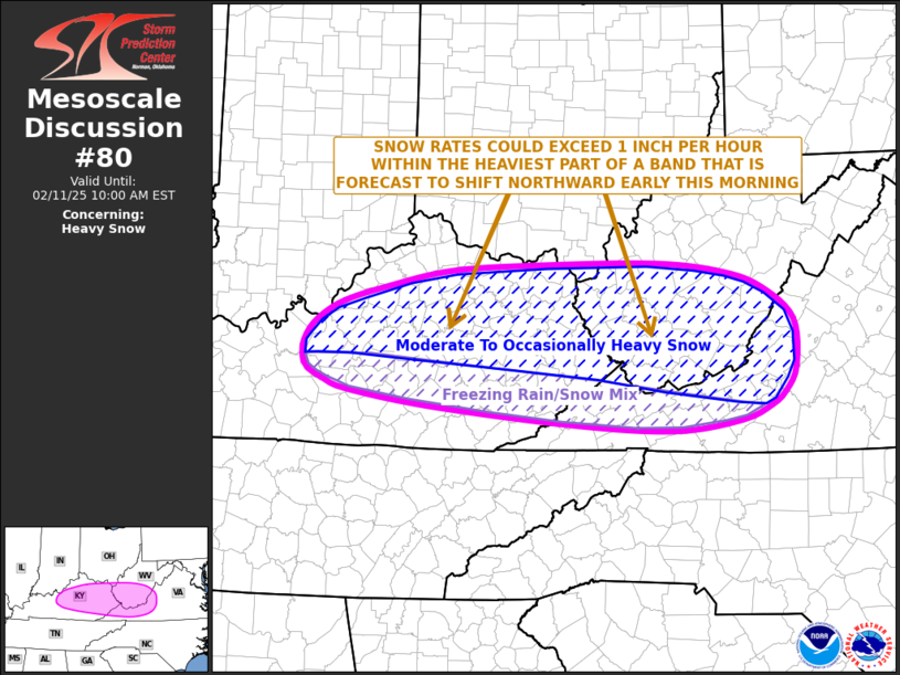
   Mesoscale Discussion 0080
   NWS Storm Prediction Center Norman OK
   0306 AM CST Tue Feb 11 2025

   Areas affected...Central and Eastern Kentucky/Western
   Virginia/Southern West Virginia

   Concerning...Heavy snow

   Valid 110906Z - 111500Z

   SUMMARY...A band of snow will continue to develop across the Ohio
   Valley and central Appalachians over the next couple of hours.
   Snowfall rates of greater than one inch per hour will be possible
   within the heavier parts of the band, with a mix of freezing rain
   and snow to the south of this band.

   DISCUSSION...Water vapor imagery shows west-southwesterly mid-level
   flow currently present across the eastern U.S., with a split
   mid-level jet pattern evident. Lift is likely being enhanced within
   the right entrance region of a mid-level jet that is analyzed in
   northern Kentucky. Widespread precipitation, in the form of a mix of
   rain, freezing rain and snow, is ongoing to the south of this
   feature from southeast Missouri eastward across Kentucky into
   western Virginia. Isentropic lift, in conjunction with strengthening
   low-level flow, is forecast to steadily increase along this
   east-to-west corridor early this morning.

   Surface temperatures are in the mid 30s F across much of central
   Kentucky, with lower 30s F in the central Appalachians. Temperatures
   will continue to gradually cool as the coverage of moderate to heavy
   precipitation increases early this morning. Within the more intense
   parts of the band, pockets of heavy snowfall are expected, with some
   locations exceeding one inch per hour. To the south of this band of
   snow, precipitation is expected to be a freezing rain and snow mix.
   After daybreak, warmer air is forecast to spread northward into
   parts of central and eastern Kentucky, which result in a changeover
   to rain in many areas.

   ..Broyles/Mosier.. 02/11/2025

   ...Please see www.spc.noaa.gov for graphic product...

   ATTN...WFO...RNK...RLX...MRX...JKL...ILN...LMK...

   LAT...LON   37228568 37328600 37428621 37508627 37668629 37858619
               38018601 38168573 38318519 38508428 38578299 38588149
               38488059 38318008 37977965 37467963 37197977 37047998
               36898037 36788127 36858262 37048453 37228568
|


 @NWSSPC