|
| Mesoscale Discussion 77 |
|
< Previous MD Next MD >
|
|
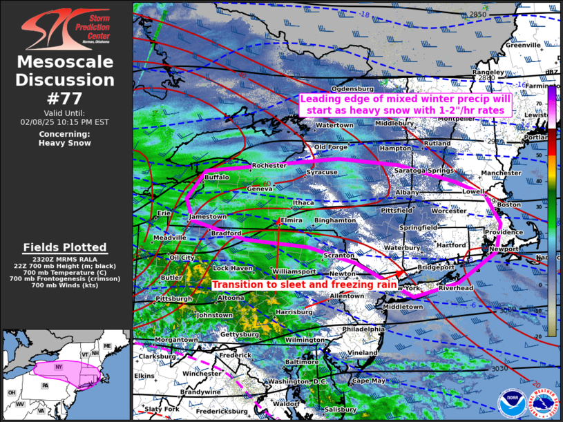
   Mesoscale Discussion 0077
   NWS Storm Prediction Center Norman OK
   0521 PM CST Sat Feb 08 2025

   Areas affected...parts of the Northeast and southern New England

   Concerning...Heavy snow

   Valid 082321Z - 090315Z

   SUMMARY...Leading corridor of winter storm across the Northeast will
   produce a heavy snow band before transitioning to sleet/freezing
   rain from the southwest. Heavy snowfall rates of 1-2 inches per hour
   are likely.

   DISCUSSION...A fast-moving swath of winter mixed precip will spread
   across the Northeast and southern New England states through the
   rest of this evening. Strengthening low to mid-level ascent will
   yield a band of heavy snow along the leading periphery of this
   precip plume where the thermodynamic profile remains entirely below
   freezing. The initial swath should emanate out of the north-central
   PA/southwest NY vicinity, where heavy snow has been observed, and
   should expand east-southeastward along the NY to PA/NJ border area
   over the next few hours. A longer-lasting deformation zone within
   the cold-conveyor region should develop east from the Lake Erie
   vicinity and move across much of southern NY during the next several
   hours. A highly consistent signal persists across daytime guidance
   with snowfall rates of 1-2 in/hr. The southern portion of the heavy
   snow swath to about the Upper DE and Lower Hudson Valleys should mix
   with/transition to sleet/freezing rain later in the evening.

   ..Grams.. 02/08/2025

   ...Please see www.spc.noaa.gov for graphic product...

   ATTN...WFO...GYX...BOX...OKX...ALY...PHI...BGM...BUF...CTP...

   LAT...LON   40677327 41357478 41657603 41777768 42117911 42547929
               43117880 43417525 43287361 42927212 42647131 42087094
               41517107 40927210 40677327
|
|
Top/All Mesoscale Discussions/Forecast Products/Home
|
|


 @NWSSPC