|
| Mesoscale Discussion 75 |
|
< Previous MD Next MD >
|
|
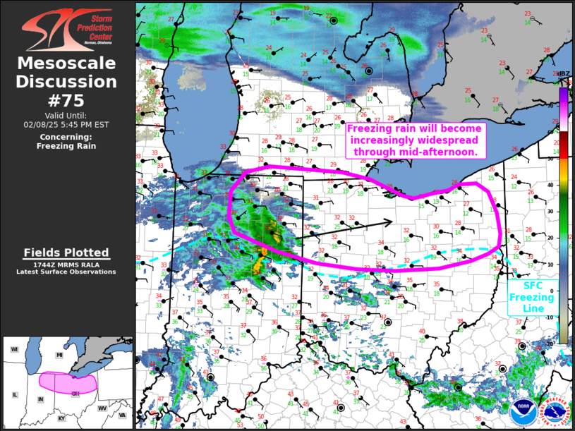
   Mesoscale Discussion 0075
   NWS Storm Prediction Center Norman OK
   1146 AM CST Sat Feb 08 2025

   Areas affected...Northeast Indiana into far southern Michigan and
   northern Ohio

   Concerning...Freezing rain

   Valid 081746Z - 082245Z

   SUMMARY...Freezing rain will gradually become more widespread across
   north/northeast Indiana and northern Ohio through the mid to late
   afternoon hours. Freezing rain rates up to 0.03 in/hour appear
   possible.

   DISCUSSION...Regional radar imagery shows a swath of stratiform
   precipitation (with embedded convective elements) becoming
   established across north-central IN as isentropic ascent increases
   within the warm conveyor belt of an intensifying mid-level low. This
   trend is expected to continue through the afternoon hours as
   warm/moist advection increases amid strengthening 925-700 mb winds.
   This mid-level warm advection will reinforce a weak warm-nose aloft,
   and should promote mainly liquid hydrometeors near the surface.
   Although surface temperatures are currently near freezing across
   northern IN/OH, dewpoints in the teens to mid 20s suggest that
   wet-bulb cooling to below freezing is likely after the initial onset
   of precipitation. This trend is already being observed at a few
   locations across northern IN with some ASOS/AWOS and mPING reports
   of freezing rain noted over the past 30-60 minutes.

   Surface temperatures from the 12 UTC HREF members appear to be
   running 1-3 F too cold compared to 17 UTC observations, which
   suggests that freezing rainfall estimates from these members/HREF
   probabilities may be too bullish. However, more recent deterministic
   solutions (HRRR/RAP) have captured surface temperature trends well
   and depict freezing rain rates of around 0.03 in/hour. These
   solutions also suggest that freezing rain potential may be greatest
   across northwest to north-central OH through late afternoon with
   accumulations up to 0.1 - 0.25 inch possible.

   ..Moore.. 02/08/2025

   ...Please see www.spc.noaa.gov for graphic product...

   ATTN...WFO...PBZ...CLE...ILN...DTX...IWX...

   LAT...LON   41538171 41628148 41638112 41498087 41158069 40818063
               40608068 40508089 40388127 40288194 40258286 40288366
               40378450 40558534 40838623 41098637 41498633 41818603
               41918551 41828398 41718339 41448268 41418245 41478206
               41538171
|
|
Top/All Mesoscale Discussions/Forecast Products/Home
|
|


 @NWSSPC