|
| Mesoscale Discussion 50 |
|
< Previous MD Next MD >
|
|
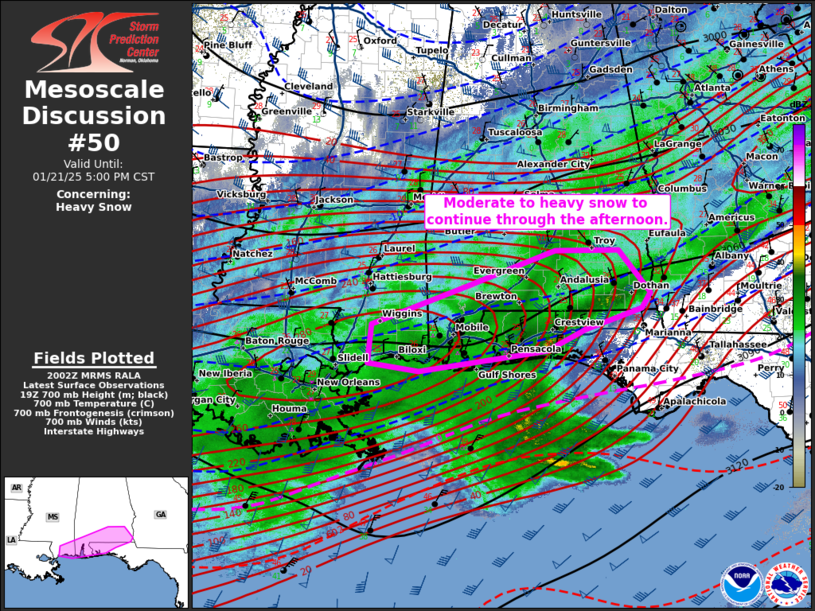
   Mesoscale Discussion 0050
   NWS Storm Prediction Center Norman OK
   0203 PM CST Tue Jan 21 2025

   Areas affected...southern Mississippi...southern Alabama...and the
   western Florida Panhandle

   Concerning...Heavy snow

   Valid 212003Z - 212300Z

   SUMMARY...Moderate to heavy snow will continue through the
   afternoon.

   DISCUSSION...A broad area of snow continues to shift east and
   northeast into portions of southern Alabama and the Florida
   Panhandle from Louisiana/southern Mississippi. Occasional sleet and
   freezing rain reports have occurred across the coast, but the main
   precipitation type has become snow area wide. Enhanced upper-level
   flow and 925-850 mb frontegenetic forcing are aiding in moderate to
   heavy snow production across these regions. Heavy snow observations
   have been reported from Gulfport, MS to Mobile, AL and into portions
   of southeastern Alabama over the last hour with visibility dropping
   to 1/4-1/2 mile. Guidance suggests snowfall rates may occasionally
   approach 1"/hr across southern Alabama near the Florida state line
   over the next 1-3 hours before tapering off later this evening as
   upper-level support shifts northward.

   ..Thornton.. 01/21/2025

   ...Please see www.spc.noaa.gov for graphic product...

   ATTN...WFO...TAE...BMX...MOB...LIX...

   LAT...LON   30808926 31278793 31768651 31768557 31218510 31028522
               30748608 30478665 30218854 30318931 30808926
|
|
Top/All Mesoscale Discussions/Forecast Products/Home
|
|


 @NWSSPC