|
| Mesoscale Discussion 48 |
|
< Previous MD Next MD >
|
|
Mesoscale Discussion 0048
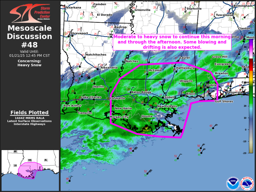
NWS Storm Prediction Center Norman OK
0846 AM CST Tue Jan 21 2025
Areas affected...Southeast Louisiana...southern Mississippi and far
southern Alabama
Concerning...Heavy snow
Valid 211446Z - 211845Z
SUMMARY...Moderate to heavy snow to continue this morning and
through the afternoon. Some blowing and drifting is also expected.
DISCUSSION...An expansive region of light to occasionally moderate
snow has spread across much of the central Gulf coast this morning.
Expect precipitation rates to increase through the late morning and
afternoon with widespread moderate to occasionally heavy snowfall
rates expected. In addition, some stronger winds, particularly
closer to the coast will lead to some blowing and drifting. Areas
with northward exposure (ex. southern short of Lake Pontchartrain)
may see some localized blizzard conditions through the day.
Some mixed precipitation is being observed from southern Terrebonne
Parish to southern St. Bernard Parish where a warm nose (seen just
below 700mb on the LIX 12Z RAOB) is slightly above freezing. 60
knots of southwesterly flow in this warm nose will attempt to
maintain its presence across the region while temperatures aloft
continue to cool. Expect the cold air to eventually win out with
snow likely across all of southern Louisiana by later this
afternoon.
..Bentley.. 01/21/2025
...Please see www.spc.noaa.gov for graphic product...
ATTN...WFO...MOB...JAN...LIX...LCH...
LAT...LON 31019159 31519076 31608898 31238781 30798754 30218756
30198828 30138865 29938871 29528885 29078901 28908909
28948999 29049087 29309164 29419195 30419196 31019159
|
|
Top/All Mesoscale Discussions/Forecast Products/Home
|
|


 @NWSSPC