Mesoscale Discussion 0042
NWS Storm Prediction Center Norman OK
0713 PM CST Mon Jan 20 2025
Areas affected...portions of far western New York
Concerning...Heavy snow
Valid 210113Z - 210415Z
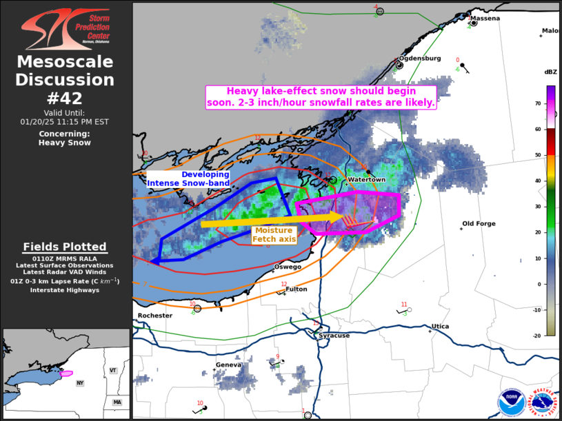
SUMMARY...Heavy snow should develop through tonight with an
approaching lake-effect snow band. 2-3 inch/hour snowfall rates are
likely, at least on an intermittent basis.
DISCUSSION...While heavy snow has recently been reported by the KART
ASOS, the ongoing snow-band should shift several miles southward
over the next couple of hours, as indicated by KTYX regional radar
data. The CWQP surface observation along the Ontario shoreline
showed an abrupt wind-shift and brief increase in speed as the
snow-band shifted to the south of this location, indicating
potential appreciable low-level convergence. The strong convergence
associated with the approaching snow-band, amid 8+ C/km 0-3 km lapse
rates, suggest that the snowfall is likely associated with
low-topped convection. The low-topped convection will benefit from a
long fetch of Lake Ontario moisture as low-level flow parallels the
lake axis this evening. Heavy lake-effect snow should begin soon,
and given convective banding with 90 percent RH in the dendritic
growth zone, production efficiency may be high enough to support at
least 2 inch/hr snowfall rates, perhaps reaching 3 inches/hr at
times.
..Squitieri.. 01/21/2025
...Please see www.spc.noaa.gov for graphic product...
ATTN...WFO...BUF...
LAT...LON 43867632 43927582 43917548 43787548 43697575 43687615
43757627 43867632
|


 @NWSSPC