|
| Mesoscale Discussion 17 |
|
< Previous MD Next MD >
|
|
Mesoscale Discussion 0017
NWS Storm Prediction Center Norman OK
0939 PM CST Sun Jan 05 2025
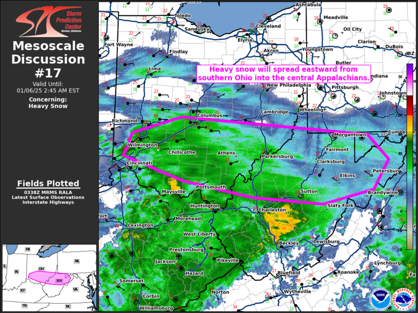
Areas affected...Parts of southern Ohio into northern West Virginia
Concerning...Heavy snow
Valid 060339Z - 060745Z
SUMMARY...Heavy snow in the vicinity of Wilmington, OH will spread
eastward into West Virginia tonight. Snowfall rates around 1 inch
per hour possible.
DISCUSSION...Strong ascent from a potent 850 mb jet as well as an
approaching shortwave trough will promote efficient dendritic growth
and snowfall rates of around 1 inch per hour tonight. Recent
observation from Lebanon, OH in conjunction with KILN radar data
suggest moderate snow with embedded heavier pockets is occurring.
Snowfall is primarily focused north of the Ohio River (per KILN
dual-pol data) and the expectation is for that to continue. These
heavier snowfall rates will eventually shift eastward into West
Virginia.
..Wendt.. 01/06/2025
...Please see www.spc.noaa.gov for graphic product...
ATTN...WFO...LWX...PBZ...RLX...ILN...
LAT...LON 39468449 39698441 39988331 39788046 39687918 39257873
38737907 38508019 38618173 38888324 39268445 39308458
39468449
|
|
Top/All Mesoscale Discussions/Forecast Products/Home
|
|


 @NWSSPC