|
| Mesoscale Discussion 7 |
|
< Previous MD Next MD >
|
|
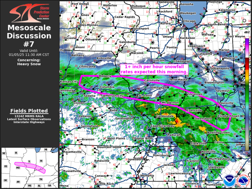
   Mesoscale Discussion 0007
   NWS Storm Prediction Center Norman OK
   0727 AM CST Sun Jan 05 2025

   Areas affected...east-central Missouri...parts of southern
   Illinois...southern Indiana...and parts of central Kentucky.

   Concerning...Heavy snow

   Valid 051327Z - 051730Z

   SUMMARY...1+ inch per hour snowfall rates are expected this morning.

   DISCUSSION...Light to  moderate snowfall has developed within a
   swath from central Missouri to central Kentucky this morning with a
   few heavy snow observations appearing recently in southern Illinois
   and southern Indiana. Expect moderate to heavy snow in a relatively
   narrow corridor north of the freezing rain from east-central
   Missouri to parts of central Kentucky. In addition to the radar
   depiction and surface observations indicating heavy snow, the 12Z
   HRRR shows a swath of significant accumulation between 13Z and 17Z.
   By midday much of this area will switch to freezing rain with the
   heavy snow swath shifted farther north during the afternoon as warm
   air advection strengthens ahead of the approaching surface low.

   ..Bentley.. 01/05/2025

   ...Please see www.spc.noaa.gov for graphic product...

   ATTN...WFO...LMK...IND...PAH...ILX...LSX...EAX...

   LAT...LON   39499336 39539107 39158827 38458601 37838508 37228527
               37158559 38248806 38799238 38929316 39109347 39499336
|
|
Top/All Mesoscale Discussions/Forecast Products/Home
|
|


 @NWSSPC