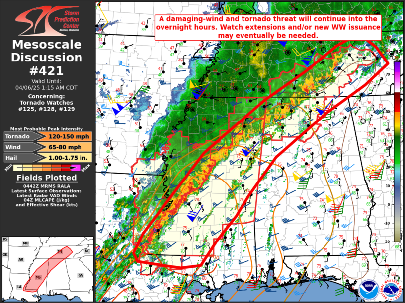
   Mesoscale Discussion 0421
   NWS Storm Prediction Center Norman OK
   1145 PM CDT Sat Apr 05 2025

   Areas affected...Eastern LA...MS...northwest AL...middle/eastern TN

   Concerning...Tornado Watch 125...128...129...

   Valid 060445Z - 060615Z

   The severe weather threat for Tornado Watch 125, 128, 129 continues.

   SUMMARY...A damaging-wind and tornado threat will continue into the
   overnight hours. Local watch extension and/or new watch issuance may
   eventually be needed.

   DISCUSSION...Long-lived supercell clusters are currently ongoing
   near the AL/TN border and into middle TN, while an increasingly
   extensive QLCS across parts of MS/LA has shown some signs of
   accelerating eastward late tonight.

   The northern clusters may eventually reach parts of eastern TN
   overnight. While buoyancy and low-level moisture weaken with
   eastward extent, some severe threat may continue into the overnight
   hours with these clusters, due to their current organized state, a
   persistently strong low-level jet, and favorable deep-layer shear.
   Some tornado threat could persist, especially with any supercells
   that continue to track near a southwest-to-northeast oriented
   outflow boundary.

   Farther south, the damaging-wind and tornado threat may increase
   with the organizing QLCS across MS and eastern LA. The 04Z JAN
   sounding depicted notable midlevel cooling and a modest
   strengthening of midlevel lapse rates, resulting in a somewhat more
   favorable buoyancy profile compared to earlier in the evening. This
   sounding and area VWPs also continue to show a favorable wind
   profile for tornadic supercells, and any embedded cells and/or
   line-embedded circulations may be capable of producing tornadoes
   overnight, including potential for a strong tornado.

   The severe threat will eventually spread east of ongoing watches.
   Local watch extensions and/or new watch issuance may eventually be
   needed during the early morning, especially if convection developing
   ahead of the QLCS is able to mature from eastern MS into western AL.

   ..Dean/Hart.. 04/06/2025

   ...Please see www.spc.noaa.gov for graphic product...

   ATTN...WFO...MRX...FFC...OHX...BMX...HUN...MEG...JAN...LIX...
   LCH...

   LAT...LON   31529171 33588997 34918817 35648689 36268591 36558520
               36218469 35778434 35258507 34598625 33488781 32518864
               32018899 31388955 30759001 30689058 30739109 30829185
               31039198 31529171

   MOST PROBABLE PEAK TORNADO INTENSITY...120-150 MPH
   MOST PROBABLE PEAK WIND GUST...65-80 MPH
   MOST PROBABLE PEAK HAIL SIZE...1.00-1.75 IN
|


 @NWSSPC