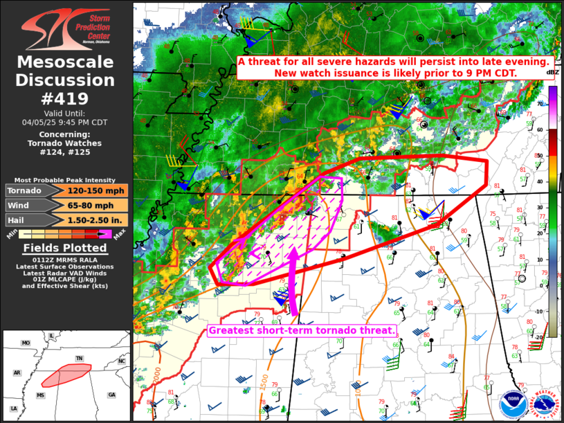
   Mesoscale Discussion 0419
   NWS Storm Prediction Center Norman OK
   0815 PM CDT Sat Apr 05 2025

   Areas affected...Northeast MS...northern AL...southern middle TN

   Concerning...Tornado Watch 124...125...

   Valid 060115Z - 060245Z

   The severe weather threat for Tornado Watch 124, 125 continues.

   SUMMARY...A threat for all severe hazards will continue into late
   evening. New watch issuance is likely by 9 PM CDT.

   DISCUSSION...A cluster of intense supercells is ongoing across
   extreme northeast MS this evening, with multiple spotter and
   radar-confirmed tornadoes over the last 60-90 minutes. A trailing
   storm cluster into north-central MS has also shown signs of
   increasing organizations. The environment from
   north-central/northeast MS into extreme northwest AL and extreme
   southwest/southern middle TN remains favorable for tornadic
   supercells, with favorably backed surface winds, rich boundary-layer
   moisture, moderate to strong buoyancy, and increasing low-level
   flow/shear (as noted on the KGWX VWP). This environment continues to
   support a threat of strong tornadoes, as well as localized large to
   very large hail and damaging winds. Any further upscale growth could
   result in potential for larger-scale swaths of damaging winds as
   storms move east-northeastward with time.

   Downstream into a larger portion of northern AL and southern middle
   TN, lower dewpoints (dropping to the lower 60s F) and weaker
   buoyancy are noted in current observations and analyses. However,
   the low-level jet will remain strong through the evening/night, and
   some moisture recovery will be possible in advance of the ongoing
   convection. This will support a continued threat of all severe
   hazards well past the scheduled 9 PM CDT expiration time of WW 124.
   As a result, new watch issuance is expected soon, which may extend
   into downstream areas of north-central/northeast AL and
   southern/eastern TN.

   ..Dean/Hart.. 04/06/2025

   ...Please see www.spc.noaa.gov for graphic product...

   ATTN...WFO...MRX...OHX...BMX...HUN...MEG...JAN...

   LAT...LON   33868898 33858951 34078963 34358931 35278791 35468737
               35488609 35408541 35108544 34628619 34208760 33938872
               33868898

   MOST PROBABLE PEAK TORNADO INTENSITY...120-150 MPH
   MOST PROBABLE PEAK WIND GUST...65-80 MPH
   MOST PROBABLE PEAK HAIL SIZE...1.50-2.50 IN
|


 @NWSSPC