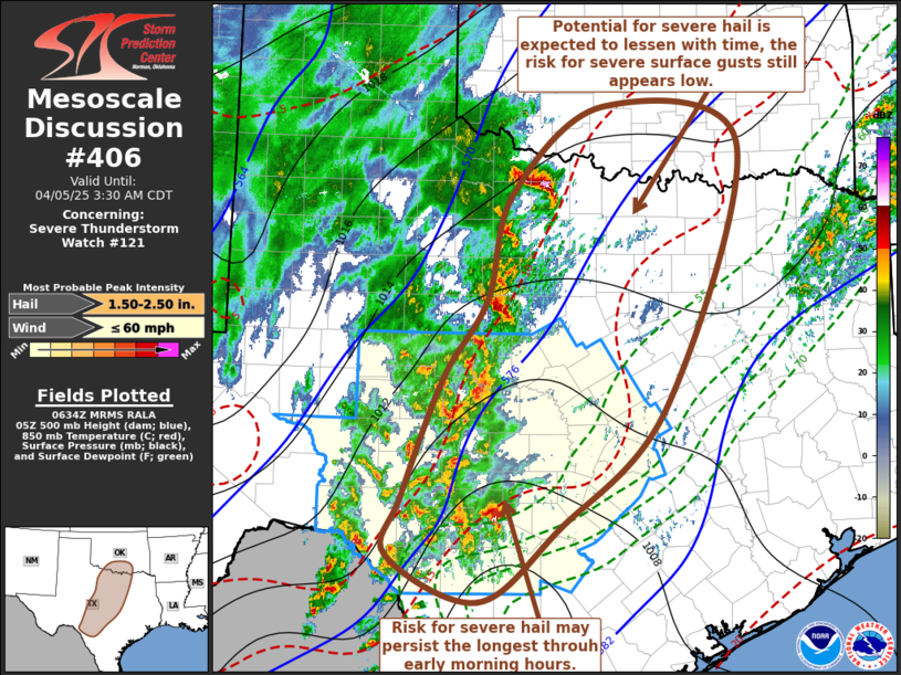
   Mesoscale Discussion 0406
   NWS Storm Prediction Center Norman OK
   0136 AM CDT Sat Apr 05 2025

   Areas affected...parts of s cntrl TX though s cntrl OK

   Concerning...Severe Thunderstorm Watch 121...

   Valid 050636Z - 050830Z

   The severe weather threat for Severe Thunderstorm Watch 121
   continues.

   SUMMARY...The risk for storms capable of producing severe hail
   continues, particularly to the west and northwest of the San Antonio
   vicinity. Farther north, into the Red River Valley, this threat is
   expected to lessen with time as storms continue to consolidate.
   Potential for activity to produce strong surface gusts appears low,
   and not likely to increase, but this remains a bit more uncertain.
   Trends will continue to be monitored for the possibility of an
   additional severe weather watch.

   DISCUSSION...Cold surface air remains entrenched along and north of
   a stalled surface front across the Ark-La-Tex vicinity, northwest of
   College Station, but south of Austin, into areas south of Del Rio.
   Although this cold air, where convection has been increasing,
   appears deeper than last night, elevated "loaded gun" type profiles
   have lingered above the stable near-surface environment.

   However, large-scale forcing for ascent and cooling aloft associated
   with another short wave perturbation overspreading the Texas South
   Plains is beginning overturn this environment.  Convection is
   becoming increasingly widespread west/northwest of Hondo TX into the
   Red River Valley, where one intense cell has been approaching the
   Wichita Falls area.

   A corridor of enhanced lower/mid-tropospheric warm advection to the
   west through northwest of San Antonio still seems to offer the most
   prolonged period of continuing discrete storm development through
   the early morning hours.  Otherwise, as convection farther to the
   west and north continues to trend less discrete, the potential for
   severe hail is expected to lessen with time.

   The potential for the development of gravity wave surface pressure
   perturbations posing increasing potential for strong surface gusts
   remains unclear.  Given the depth of surface-based cold air, this
   still seems low, but it might not be completely negligible.

   ..Kerr.. 04/05/2025

   ...Please see www.spc.noaa.gov for graphic product...

   ATTN...WFO...FWD...OUN...EWX...SJT...

   LAT...LON   33689920 34699797 34289611 31239712 29829855 28989962
               29520084 30180065 31550011 32469953 33689920

   MOST PROBABLE PEAK WIND GUST...UP TO 60 MPH
   MOST PROBABLE PEAK HAIL SIZE...1.50-2.50 IN
|


 @NWSSPC