|
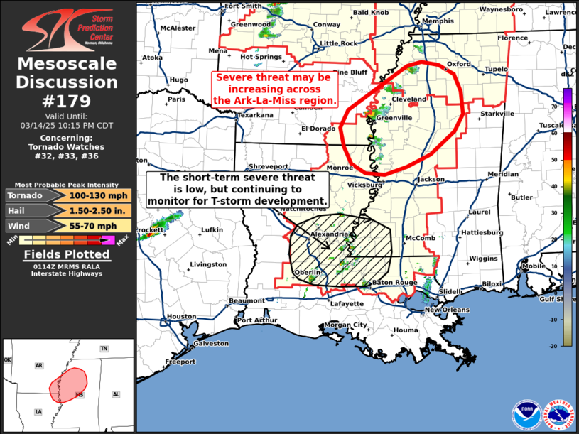
| Mesoscale Discussion 179 |
|
[an error occurred while processing this directive]
|

|
   Mesoscale Discussion 0179
   NWS Storm Prediction Center Norman OK
   0815 PM CDT Fri Mar 14 2025

   Areas affected...The Ark-La-Miss region

   Concerning...Tornado Watch 32...33...36...

   Valid 150115Z - 150315Z

   The severe weather threat for Tornado Watch 32, 33, 36 continues.

   SUMMARY...The severe threat appears to be increasing across the
   Ark-La-Miss region as thunderstorms continue to intensify. Further
   south, the near-term severe threat appears low across eastern
   Louisiana into southwest Mississippi, though convective development
   remains possible.

   DISCUSSION...Thunderstorms continue to develop across southeast AR
   into western MS with latest GOES imagery showing cloud top heights
   exceeding regional equilibrium levels (37-38 kft). This suggests
   that storms are beginning to fully realize the thermodynamic
   environment and should steadily become more organized given the very
   favorable kinematic profiles depicted by regional VWPs.
   Consequently, the severe threat may be increasing for parts of
   southeast AR and western MS.

   Further south across eastern LA into southwest MS, initial storms
   that developed during the 22-00 UTC period have since collapsed
   despite a favorable convective environment. This was possibly due to
   inadequate forcing for ascent that did not allow storms to
   sufficiently intensify and become self-sufficient. Since then,
   additional attempts at convective initiation have been noted, but
   have been unsuccessful. For the short term, the severe threat
   remains low, but continued (though weak) isentropic ascent within a
   very weakly capped and strongly sheared environment (per the 00 UTC
   LIX sounding) and bubbling cumulus across the region suggest that
   severe convection remains possible within the next 2-5 hours (though
   confidence in this potential is limited).

   ..Moore.. 03/15/2025

   ...Please see www.spc.noaa.gov for graphic product...

   ATTN...WFO...MEG...JAN...LZK...

   LAT...LON   32469085 32509126 32669155 32979171 33329180 33639163
               34429035 34509003 34448967 34268933 33968919 33548915
               33238935 32828986 32609037 32469085
|
|
Top/All Mesoscale Discussions/Forecast Products/Home
|
|


