|
| Mesoscale Discussion 2160 |
|
< Previous MD Next MD >
|
|
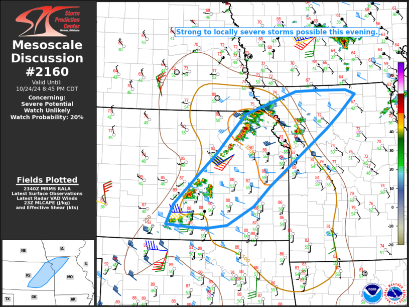
   Mesoscale Discussion 2160
   NWS Storm Prediction Center Norman OK
   0642 PM CDT Thu Oct 24 2024

   Areas affected...south-central into northeast KS...northwest into
   north-central MO

   Concerning...Severe potential...Watch unlikely

   Valid 242342Z - 250145Z

   Probability of Watch Issuance...20 percent

   SUMMARY...Strong to locally severe storms will be possible this
   evening, with a threat of isolated hail and strong to severe wind
   gusts.

   DISCUSSION...Storm coverage is increasing early this evening from
   central KS into northwest MO. Storms to the north/northeast of
   Kansas City have developed just to northeast of a warm front and are
   likely somewhat elevated. Persistent low-level warm/moist advection
   will help to sustain these storms as they approach north-central MO.
   Moderate elevated buoyancy (with MUCAPE of 1000-1500 J/kg) and
   sufficient deep-layer shear could support marginal supercell
   structures with a threat for isolated large hail. Also, despite this
   convection being somewhat elevated, a dry near-surface layer beneath
   the elevated moist plume could support some stronger wind gusts this
   evening as storms spread northeastward.

   Farther west, scattered storm development is ongoing from
   south-central into northeast KS, as a southeastward-moving cold
   front begins to intercept a pre-frontal surface trough and
   relatively greater instability. While low-level moisture remains
   rather limited, strong diurnal heating has resulted in MLCAPE
   increasing into the 500-1000 J/kg range, along with weakening
   MLCINH. Increasing deep-layer flow/shear associated with an
   approaching midlevel shortwave trough will support some organized
   convection through the evening.

   Rather strong low-level flow (30-40 kt in the 1-3 km layer per
   regional VWPs) and steep low-level lapse rates will support
   potential for strong to locally severe gusts within this regime,
   especially if any organized clustering occurs. Isolated hail will
   also be possible, especially into east-central/northeast KS and
   northwest MO, where somewhat more favorable moisture and buoyancy
   will be in place.

   ..Dean/Hart.. 10/24/2024

   ...Please see www.spc.noaa.gov for graphic product...

   ATTN...WFO...EAX...OAX...TOP...ICT...

   LAT...LON   37829798 38729706 39009674 39919589 40459437 40469379
               40479286 40379259 39899309 39569346 39029418 38269515
               37799564 37359641 37279699 37289743 37369820 37829798
|
|
Top/All Mesoscale Discussions/Forecast Products/Home
|
|


 @NWSSPC