|
| Mesoscale Discussion 2102 |
|
< Previous MD Next MD >
|
|
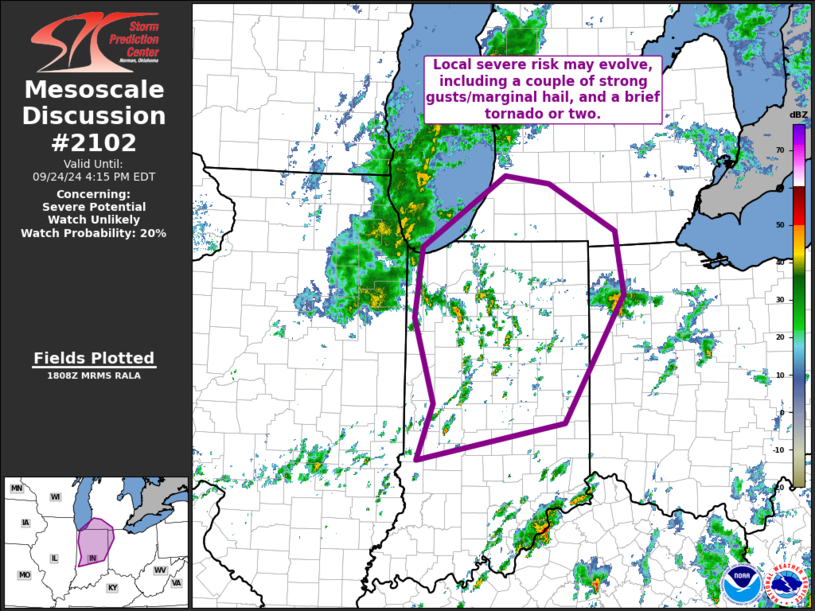
   Mesoscale Discussion 2102
   NWS Storm Prediction Center Norman OK
   0110 PM CDT Tue Sep 24 2024

   Areas affected...southern Lower Michigan into Indiana and
   northwestern Ohio

   Concerning...Severe potential...Watch unlikely

   Valid 241810Z - 242015Z

   Probability of Watch Issuance...20 percent

   SUMMARY...Local risk for a couple of strong gusts and marginal hail,
   and possibly a brief tornado or two, is expected to evolve across
   the southern Lower Michigan/Indiana/northwestern Ohio vicinity this
   afternoon.  Isolated/marginal nature of risk may preclude the need
   for WW issuance, but we will continue to monitor evolution.

   DISCUSSION...Latest visible satellite imagery shows cloud cover
   decreasing slightly ahead of a mid-level cyclonic circulation moving
   northeastward across the area.  This, combined with associated/cool
   temperatures aloft and modest afternoon heating has resulted in
   development of 500 to 1000 J/kg mixed-layer CAPE.

   Within the zone of broad/background ascent, some convective increase
   is noted over the past hour, with an associated uptick in lightning.
    This trend should continue over the next couple of hours -- likely
   resulting in a few relatively vigorous/low-topped storms which may
   prove capable of producing marginal hail and a strong gust or two.
   A brief tornado or two will also be possible, particularly across
   southern Lower Michigan and northern Indiana where low-level flow is
   backed/east-southeasterly near and north of a weak warm front.

   At this time, overall risk is expected to remain localized -- too
   isolated for serious WW consideration.  However, we will continue to
   monitor short-term trends across this area that could warrant
   reconsideration of the need for a watch.

   ..Goss/Guyer.. 09/24/2024

   ...Please see www.spc.noaa.gov for graphic product...

   ATTN...WFO...ILN...IWX...GRR...IND...LOT...

   LAT...LON   41688728 42498604 42418538 41878439 41148428 39698516
               39278735 39928710 40898740 41688728
|
|
Top/All Mesoscale Discussions/Forecast Products/Home
|
|


 @NWSSPC