|
| Mesoscale Discussion 2051 |
|
< Previous MD Next MD >
|
|
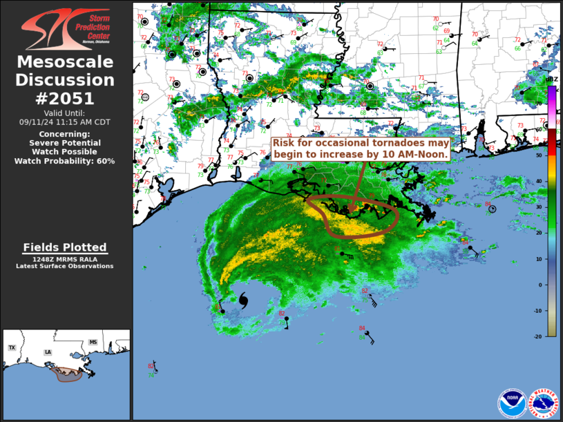
   Mesoscale Discussion 2051
   NWS Storm Prediction Center Norman OK
   0750 AM CDT Wed Sep 11 2024

   Areas affected...southeastern Louisiana coastal areas

   Concerning...Severe potential...Watch possible

   Valid 111250Z - 111615Z

   Probability of Watch Issuance...60 percent

   SUMMARY...The risk for occasional tornadoes may begin to increase
   near southeastern Louisiana coastal areas by late morning (10
   AM-Noon).  Trends are being monitored for the possibility of a
   tornado watch.

   DISCUSSION...The center of Francine has been migrating across and
   northeast of the Gunnison Oil Platform vicinity of the northwestern
   Gulf of Mexico during the past hour or so, and is still roughly 170
   miles from its forecast south central Louisiana coastal landfall
   later today.  However, the leading edge of a broader convective
   precipitation shield preceding Francine is beginning to overspread
   coastal areas, accompanied by saturating thermodynamic profiles with
   lapse rates trending moist adiabatic in mid-levels.

   In the wake of this regime, and with the continued approach of
   Francine, model forecast soundings suggest that a subtle increase in
   boundary-layer temperatures and dew points may contribute to modest
   destabilization by midday along coastal areas from west of
   Boothville into the Vermilion Bay vicinity.  It appears that this
   will coincide with more notable strengthening of low-level wind
   fields, which are forecast to contribute to enlarging low-level
   hodographs increasingly supportive of convection with embedded
   low-level mesocyclones potentially capable of producing tornadoes.

   ..Kerr/Edwards.. 09/11/2024

   ...Please see www.spc.noaa.gov for graphic product...

   ATTN...WFO...LIX...LCH...

   LAT...LON   29459176 29519097 29258988 28839012 28759117 29189143
               29459176
|
|
Top/All Mesoscale Discussions/Forecast Products/Home
|
|


 @NWSSPC