|
| Mesoscale Discussion 2049 |
|
< Previous MD Next MD >
|
|
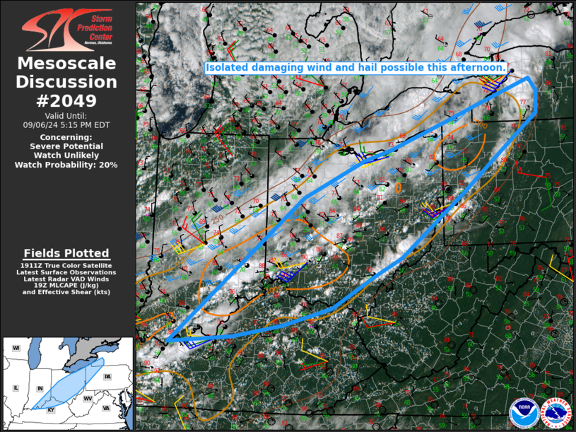
   Mesoscale Discussion 2049
   NWS Storm Prediction Center Norman OK
   0218 PM CDT Fri Sep 06 2024

   Areas affected...Parts of OH into southeast IN...northern
   KY...western PA...northern WV Panhandle...far western NY

   Concerning...Severe potential...Watch unlikely

   Valid 061918Z - 062115Z

   Probability of Watch Issuance...20 percent

   SUMMARY...Isolated damaging wind and hail are possible this
   afternoon.

   DISCUSSION...Convection is gradually increasing this afternoon from
   parts of the Ohio Valley to near Lake Erie, along/ahead of a cold
   front and in advance of a seasonably deep upper-level trough that is
   digging southeastward into the region. Convergence along the front
   is currently rather weak, but may increase later this afternoon in
   response to the digging upper trough. This should allow for an
   increase in storm coverage through the afternoon.

   Deep-layer flow will also gradually increase across the region in
   response to the digging trough, as MLCAPE approaches 1000 K/kg in
   areas where stronger heating persists. Effective shear will increase
   to 25-30 kt ahead of the front (generally weaker with southward
   extent), with somewhat greater effective shear immediately behind
   the leading wind shift, where surface winds become northwesterly but
   relatively favorable moisture and instability will persist in
   advance of the deeper cool/dry airmass moving in from the northwest.

   Midlevel lapse rates are generally weak, but modestly supportive
   buoyancy and effective shear will support potential for a few
   organized storms later this afternoon. Locally damaging winds appear
   to be the most likely hazard, especially where stronger
   heating/mixing has occurred ahead of the front. Some hail may be
   possible with any sustained discrete cells.

   ..Dean/Mosier.. 09/06/2024

   ...Please see www.spc.noaa.gov for graphic product...

   ATTN...WFO...BUF...CTP...PBZ...RLX...CLE...JKL...ILN...LMK...
   IND...PAH...

   LAT...LON   37888706 40618389 41318241 41508176 41538168 42018045
               42307966 42787832 42547814 42147817 41317925 40727998
               39498152 39178214 38568320 38238438 38018555 37888706
|
|
Top/All Mesoscale Discussions/Forecast Products/Home
|
|


 @NWSSPC