|
| Mesoscale Discussion 2036 |
|
< Previous MD Next MD >
|
|
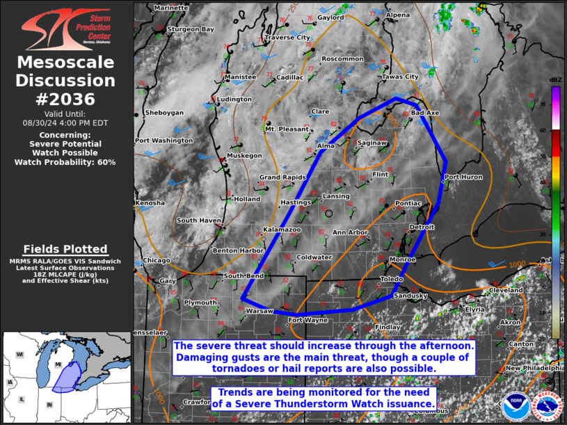
   Mesoscale Discussion 2036
   NWS Storm Prediction Center Norman OK
   0125 PM CDT Fri Aug 30 2024

   Areas affected...portions of eastern Lower Michigan into extreme
   northeast Indiana and extreme northwest Ohio

   Concerning...Severe potential...Watch possible

   Valid 301825Z - 302000Z

   Probability of Watch Issuance...60 percent

   SUMMARY...The severe threat will increase through the afternoon
   across portions of eastern Lower Michigan and immediate surrounding
   areas. Severe gusts are the main concern, though a couple of
   tornadoes or instances of large hail also cannot be ruled out. A WW
   issuance may be needed in the next few hours pending favorable
   convective trends.

   DISCUSSION...Adequate insolation has supported surface temperatures
   reaching the mid 80s F amid low 70s F dewpoints, contributing to
   nearly 3000 J/kg SBCAPE (per 17Z mesoanalysis, and when modifying
   the 12Z DTX observed sounding). However, both the mesoanalysis and
   the modified sounding show MLCAPE under 500 J/kg with appreciable
   MLCINH remaining given some 850 mb dry-air advection from the
   southwest. Nonetheless, continued diurnal heating and the approach
   of a 500 mb trough and accompanying surface cold front will support
   an increase in thunderstorm coverage and intensity into the
   afternoon. The approach of the upper trough will encourage some
   strengthening/veering of tropospheric winds, resulting in 30 kts of
   effective bulk shear and modestly elongated/curved hodographs.
   Multicells and line segments are the main storm modes expected,
   though a transient supercell is also possible. Damaging gusts are
   the main threat, though a couple of tornadoes or instances of severe
   hail could also occur. Convective trends will continue to be
   monitored for the need of a WW issuance.

   ..Squitieri/Bunting.. 08/30/2024

   ...Please see www.spc.noaa.gov for graphic product...

   ATTN...WFO...CLE...DTX...IWX...GRR...

   LAT...LON   41468590 42578510 43358456 43798388 44058323 43958288
               43228237 42698250 41958305 41508333 41328399 41268496
               41298539 41468590
|
|
Top/All Mesoscale Discussions/Forecast Products/Home
|
|


 @NWSSPC