|
| Mesoscale Discussion 1975 |
|
< Previous MD Next MD >
|

|
   Mesoscale Discussion 1975
   NWS Storm Prediction Center Norman OK
   0844 PM CDT Thu Aug 22 2024

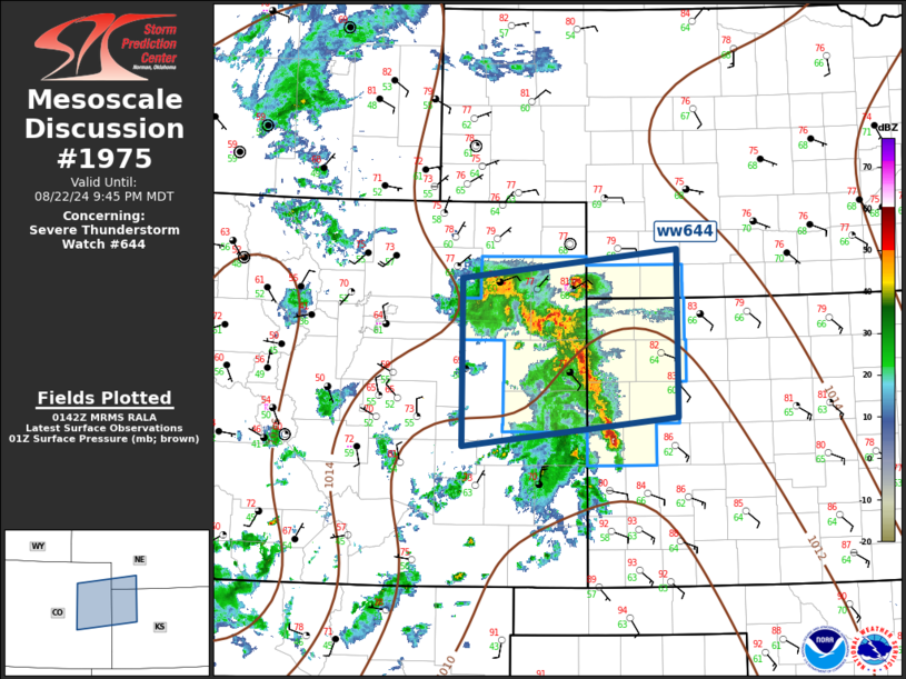
   Areas affected...Central High Plains

   Concerning...Severe Thunderstorm Watch 644...

   Valid 230144Z - 230345Z

   The severe weather threat for Severe Thunderstorm Watch 644
   continues.

   SUMMARY...Wind/hail threat will spread across eastern portions of
   ww644 over the next several hours.

   DISCUSSION...Scattered high-based convection that initiated over the
   higher terrain of central/southern CO has matured into an MCS that
   is now advancing into northwest KS. Over the last hour or so, a weak
   MCV appears to have developed which is now just south of AKO,
   supporting the overall organization of this complex. 1km AGL
   southeasterly inflow across western KS is on the order of 25-30kt,
   which will encourage propagation across at least the western
   portions of the main instability corridor. 00z soundings from the
   central High Plains exhibit substantial CINH, and further
   boundary-layer stabilization is expected as surface temperatures
   cool. Given the organization of this complex, further propagation is
   likely into the eastern-most portions of the watch; however, updraft
   intensities have likely peaked and gradual weakening can be expected
   by 03-04z. Until then, damaging winds will likely be the primary
   risk.

   ..Darrow.. 08/23/2024

   ...Please see www.spc.noaa.gov for graphic product...

   ATTN...WFO...LBF...GLD...PUB...BOU...

   LAT...LON   40200372 40500082 38750082 38450370 40200372
|
|
Top/All Mesoscale Discussions/Forecast Products/Home
|
|


