|
| Mesoscale Discussion 1973 |
|
< Previous MD Next MD >
|
|
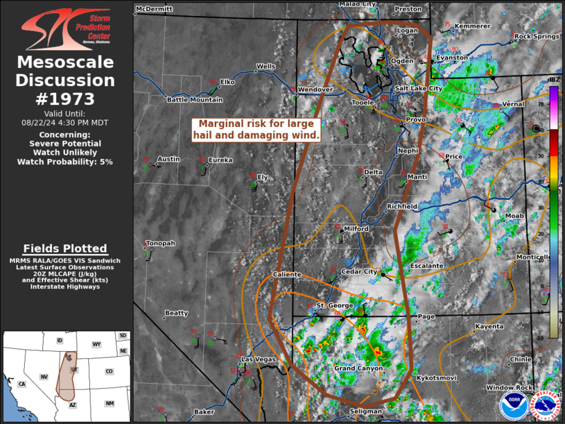
   Mesoscale Discussion 1973
   NWS Storm Prediction Center Norman OK
   0328 PM CDT Thu Aug 22 2024

   Areas affected...Portions of Utah and Northern Arizona

   Concerning...Severe potential...Watch unlikely

   Valid 222028Z - 222230Z

   Probability of Watch Issuance...5 percent

   SUMMARY...Marginal risk of large hail and damaging wind.

   DISCUSSION...Thunderstorm activity is expected to continue and
   expand in coverage across portions of northern Arizona into Utah
   this afternoon/evening. Mid-level west to southwesterly flow around
   30-40 kts through the base of a trough across the Pacific Northwest
   atop southeasterly flow near the surface is supporting modest shear
   around 30-35 kts across northwestern Arizona into central/northern
   Utah. Daytime heating has resulted in MLCAPE around 500-1500 J/kg
   across northwestern Arizona. In this region a few more organized
   transient supercells have been observed on radar, exhibiting broad
   weak rotation at times. Generally weak low-level flow and
   southwesterly mean flow led to back building cells along the
   terrain. Some instances of strong to severe gusts and severe hail
   will be possible given deep layer shear for organization and steep
   low to mid-level lapse rates. Overall, this threat is expected to
   remain localized and watch issuance is not anticipated.

   ..Thornton/Hart.. 08/22/2024

   ...Please see www.spc.noaa.gov for graphic product...

   ATTN...WFO...RIW...FGZ...SLC...VEF...LKN...

   LAT...LON   36951454 37681438 39071408 40441358 41621307 41891287
               41951198 41891135 41671104 40321121 39671137 38431188
               37011162 36431158 36081156 35621191 35471255 35671333
               36171407 36951454
|
|
Top/All Mesoscale Discussions/Forecast Products/Home
|
|


 @NWSSPC