|
| Mesoscale Discussion 1939 |
|
< Previous MD Next MD >
|
|
Mesoscale Discussion 1939
NWS Storm Prediction Center Norman OK
0223 AM CDT Sun Aug 18 2024
Areas affected...South-Central SD...North-Central NE
Concerning...Severe potential...Watch unlikely
Valid 180723Z - 181000Z
Probability of Watch Issuance...20 percent
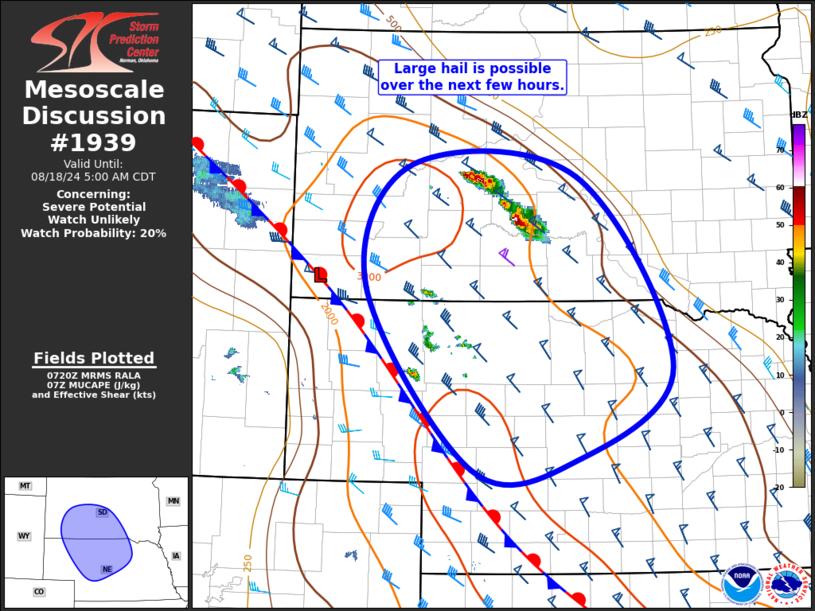
SUMMARY...Large hail is possible across south-central South Dakota
and adjacent north-central Nebraska for the next few hours.
DISCUSSION...Isolated thunderstorms have developed across
south-central SD amid the warm-air advection regime fostered by the
modest low-level jet over the central High Plains. Moderate to
strong buoyancy (i.e. MUCAPE from 2000 to 3000 J/kg) is in place
from southwest/south-central SD into central NE, with these storms
developing near the maximum within this corridor. There is a sharp
gradient in buoyancy with northeastward extent, with MUCAPE dropping
from 3000 J/kg across southwest SD to less than 500 J/kg across
eastern NE. This lack of buoyancy across eastern SD will likely
limit storm development to the northeast of the ongoing storms until
later this morning. The northwesterly deep-layer vertical shear
suggests a southeasterly storm motion will be favored as updrafts
mature. Large hail is possible with these storms for the next hour
or two.
Additional thunderstorm development appears possible to the
southwest of the ongoing storms, fostered by a combination of
warm-air advection and strengthening large-scale ascent attendant to
a shortwave trough currently progressing northeastward through the
central Rockies. The aforementioned corridor of moderate to strong
buoyancy will support strong updrafts, with the moderate deep-layer
vertical shear supporting updraft organization. Consequently, a few
storms may become strong enough to produce large hail.
..Mosier/Smith.. 08/18/2024
...Please see www.spc.noaa.gov for graphic product...
ATTN...WFO...FSD...ABR...GID...LBF...UNR...CYS...
LAT...LON 44480225 44359977 42269836 41249980 41140134 43130293
44480225
|
|
Top/All Mesoscale Discussions/Forecast Products/Home
|
|


 @NWSSPC