|
| Mesoscale Discussion 1907 |
|
< Previous MD Next MD >
|

|
   Mesoscale Discussion 1907
   NWS Storm Prediction Center Norman OK
   0114 PM CDT Thu Aug 15 2024

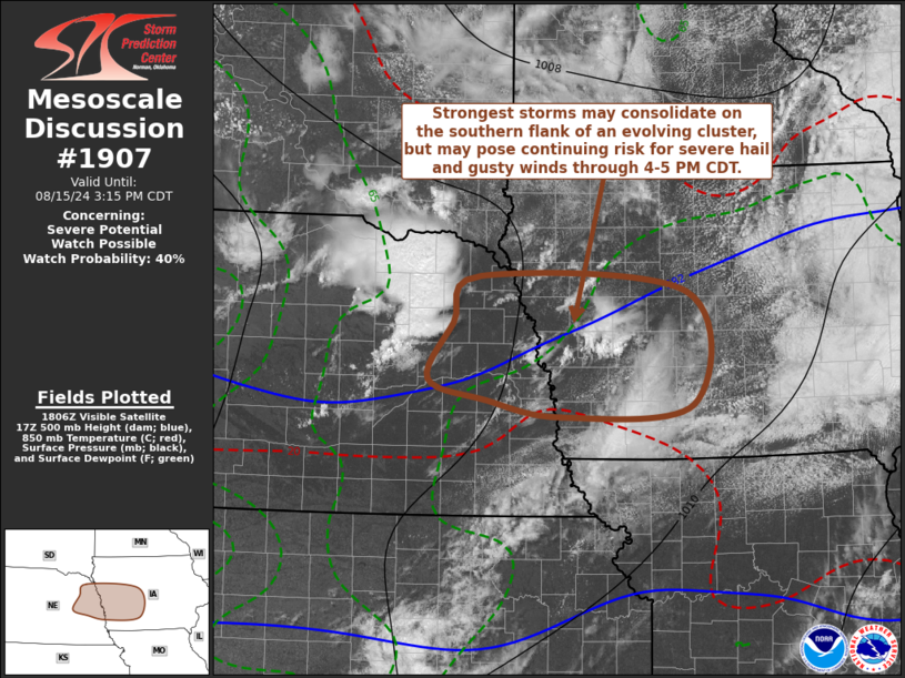
   Areas affected...parts of eastern Nebraska into western Iowa

   Concerning...Severe potential...Watch possible

   Valid 151814Z - 152015Z

   Probability of Watch Issuance...40 percent

   SUMMARY...A developing cluster of thunderstorms, with strongest
   storms gradually consolidating on its southern flank, may continue
   to pose a risk for severe hail and a few strong surface gusts across
   the Interstate 80 corridor of western Iowa and adjacent eastern
   Nebraska through 4-5 PM CDT.

   DISCUSSION...Thunderstorm activity has undergone a recent increase
   near the Norfolk vicinity of northeastern Nebraska.  This is
   occurring in the presence of weak low-level cold advection, to the
   west of a surface trough axis shifting southeastward through the
   central Great Plains and mid to lower Missouri Valley region.
   However, the boundary-layer remains relatively moist, and appears
   supportive of CAPE on the order of 1000-1500 J/kg, beneath the
   leading edge of a -10 to -12C 500 mb cold pool, associated with a
   notable mid-level perturbation pivoting southeastward and eastward
   across southern portions of the mid Missouri Valley.  Generally
   within the exit region of a 40-70+ kt westerly jet streak in the
   500-300 mb layer, deep-layer shear appears sufficient for supercell
   structures with potential to produce severe hail.  With continuing
   insolation in advance of activity, it is possible that vigorous
   thunderstorm development will be maintained and perhaps increase
   further as the mid-level forcing spreads into the Interstate 80
   corridor of western Iowa through 21-22Z.

   ..Kerr/Thompson.. 08/15/2024

   ...Please see www.spc.noaa.gov for graphic product...

   ATTN...WFO...DMX...FSD...OAX...GID...

   LAT...LON   41959723 42419687 42259409 41119401 40999577 41179679
               41389756 41959723
|
|
Top/All Mesoscale Discussions/Forecast Products/Home
|
|


