|
| Mesoscale Discussion 1900 |
|
< Previous MD Next MD >
|

|
   Mesoscale Discussion 1900
   NWS Storm Prediction Center Norman OK
   0300 PM CDT Wed Aug 14 2024

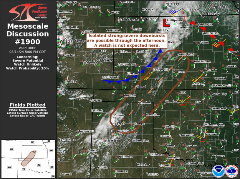
   Areas affected...Portions of the TX/OK Panhandles...far northwest
   OK...and south-central KS

   Concerning...Severe potential...Watch unlikely

   Valid 142000Z - 142200Z

   Probability of Watch Issuance...20 percent

   SUMMARY...Isolated strong/severe downbursts are possible through the
   afternoon, though a watch is not expected here. The severe threat
   will increase later this afternoon/evening with northeastward
   extent.

   DISCUSSION...Boundary-layer cumulus is gradually deepening along a
   pre-frontal heat axis/confluence zone extending from the TX
   Panhandle northeastward into south-central KS. Over the TX
   Panhandle, cumulus is deeper and isolated convective initiation is
   underway. During the next few hours, continued
   heating/destabilization should aid in isolated to widely scattered
   high-based thunderstorms along the heat axis, and potentially along
   a slow-moving cold front over southwest KS. Surface temperatures
   climbing into the upper 90s/lower 100s and associated steep
   low-level lapse rates will support strong to locally severe
   downbursts with any high-based storms that can initiate through the
   afternoon. Modest deep-layer flow/shear (especially from the TX
   Panhandle into south-central KS) should generally limit storm
   longevity, and generally weak large-scale ascent casts uncertainty
   on overall storm coverage. Therefore, a watch is not expected for
   this area.

   Both instability and deep-layer wind shear increase with
   northeastward extent into central/northeast KS, and any storms that
   spread/develop into this area will pose a greater severe threat
   later this afternoon into the evening.

   ..Weinman/Thompson.. 08/14/2024

   ...Please see www.spc.noaa.gov for graphic product...

   ATTN...WFO...ICT...OUN...DDC...AMA...

   LAT...LON   37449851 35280095 35230148 35370188 35670213 35960211
               36260178 37490047 38149975 38459943 38599922 38629887
               38579848 38219816 37899819 37449851
|
|
Top/All Mesoscale Discussions/Forecast Products/Home
|
|


