|
| Mesoscale Discussion 1889 |
|
< Previous MD Next MD >
|

|
   Mesoscale Discussion 1889
   NWS Storm Prediction Center Norman OK
   0634 PM CDT Mon Aug 12 2024

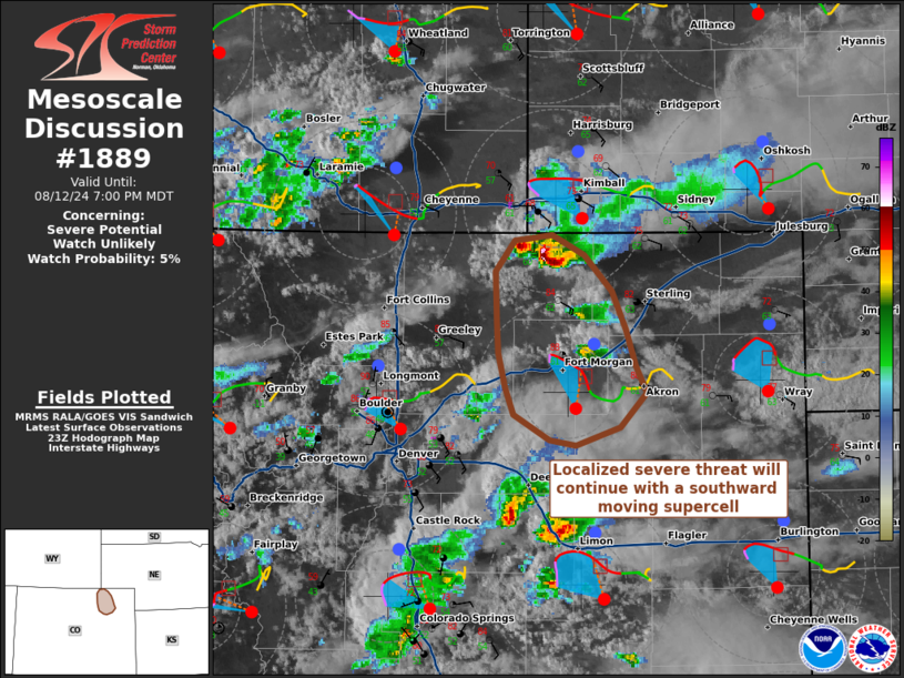
   Areas affected...Northeastern Colorado

   Concerning...Severe potential...Watch unlikely

   Valid 122334Z - 130100Z

   Probability of Watch Issuance...5 percent

   SUMMARY...A supercell thunderstorm capable of damaging winds, hail,
   and perhaps a tornado is tracking southward across portions of
   northeast Colorado. Given the isolated nature of this storm, weather
   watch issuance is not likely.

   DISCUSSION...The severe weather threat associated with a
   southward-moving supercell in northeast Colorado may persist for the
   next 1-2 hours. The storm has exhibited signs of prolonged low-level
   rotation, has produced 2.00 inch hail, and is moving into an
   environment that will continue to support updraft rotation. Forecast
   proximity hodographs indicate there is sufficient curvature of the
   low-level flow and streamwise vorticity to support continued
   low-level mesocyclone development and cycling. Both the curvature
   and magnitude of the low-level hodograph is expected to increase as
   the nocturnal low-level jet strengthens with the decoupling of the
   boundary-layer. However, recent radar trends suggest the storm is
   struggling to stay ahead of its own outflow, where temperatures are
   15-20 F cooler than unmodified inflow. This supercell will likely
   undergo several phases of organized low-level rotation, followed by
   surging outflow, until the boundary-layer eventually stabilizes this
   evening and convection becomes more elevated in nature.

   ..Halbert/Wendt/Edwards.. 08/12/2024

   ...Please see www.spc.noaa.gov for graphic product...

   ATTN...WFO...BOU...

   LAT...LON   40790427 40960414 40980387 40870363 40680344 40460333
               40260326 40120319 39920338 39830370 39860389 40000414
               40140421 40330425 40510427 40790427
|
|
Top/All Mesoscale Discussions/Forecast Products/Home
|
|


