|
| Mesoscale Discussion 1867 |
|
< Previous MD Next MD >
|

|
   Mesoscale Discussion 1867
   NWS Storm Prediction Center Norman OK
   0212 PM CDT Thu Aug 08 2024

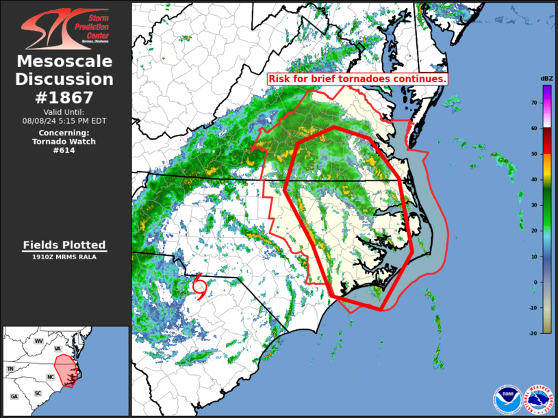
   Areas affected...eastern North Carolina into southeastern Virginia

   Concerning...Tornado Watch 614...

   Valid 081912Z - 082115Z

   The severe weather threat for Tornado Watch 614 continues.

   SUMMARY...Brief tornado risk continues across portions of Tornado
   Watch 614.

   DISCUSSION...Recent radar loop shows little movement of the center
   of Tropical Storm Debby (still in the vicinity of the North
   Carolina/South Carolina border southeast of Charlotte, NC), while
   individual cells in convective bands within the northeastern
   quadrant of the storm having become a bit stronger in general over
   the past couple of hours.  This intensification is likely related to
   modest heating through some cloud breaks, that has allowed weak
   destabilization/small increases in mixed-layer CAPE to occur.  In
   tandem with this cellular increase, and given the favorable
   background low-level flow field, an uptick in coverage of storms
   exhibiting low-level rotation has been observed overall.  The most
   active area in terms of low-level circulations has been in the
   vicinity of the northeastern North Carolina/southeastern Virginia
   border region, where rotating cells continue moving northwestward,
   along with occasional radar hints of potential/brief tornadoes.

   Overall, expect the situation to remain generally steady-state, with
   continued risk for brief tornadoes likely to persist over the next
   several hours.

   ..Goss.. 08/08/2024

   ...Please see www.spc.noaa.gov for graphic product...

   ATTN...WFO...AKQ...MHX...RAH...ILM...RNK...

   LAT...LON   34517765 35407806 36367868 37207841 37507760 37297682
               36597618 35287590 34257660 34517765
|
|
Top/All Mesoscale Discussions/Forecast Products/Home
|
|


