|
| Mesoscale Discussion 1806 |
|
< Previous MD Next MD >
|

|
   Mesoscale Discussion 1806
   NWS Storm Prediction Center Norman OK
   0423 PM CDT Sat Aug 03 2024

   Areas affected...portions of the southern High Plains

   Concerning...Severe potential...Watch unlikely

   Valid 032123Z - 032330Z

   Probability of Watch Issuance...20 percent

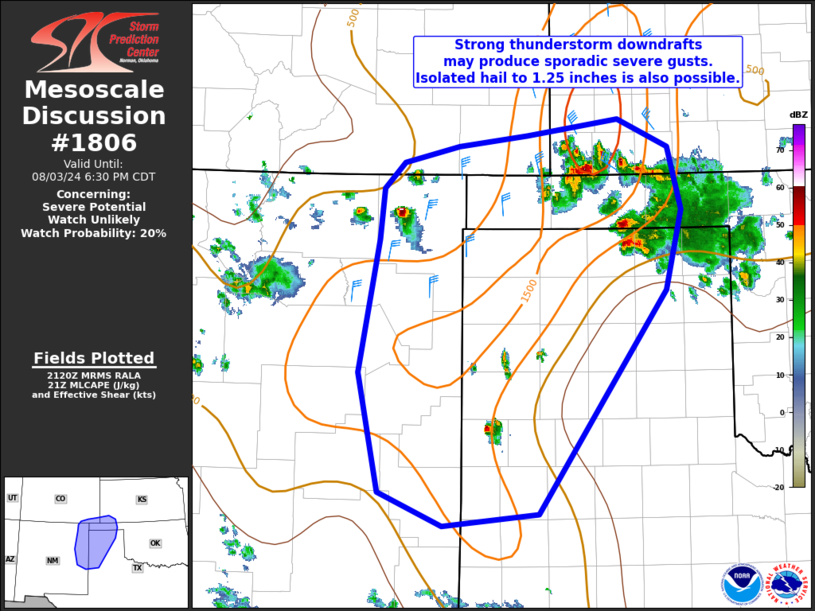
   SUMMARY...Isolated strong to severe thunderstorms may produce
   sporadic strong gusts around 50-65 mph and hail up to 1.25 inch
   diameter into this evening.

   DISCUSSION...Scattered thunderstorms have developed this afternoon
   under the influence of a southward developing convectively enhanced
   vorticity max over eastern CO/western KS.  While moisture is
   limited, steep midlevel lapse rates are contributing to 1000-1500
   J/kg MLCAPE. Aided by the vorticity max and vertically veering wind
   profiles, effective shear magnitudes greater than 35 kt will support
   sporadic organized convection despite modest boundary-layer
   moisture/instability. Modified 12z and forecast soundings indicated
   a deeply mixed boundary layer with inverted-v sub-cloud
   thermodynamic profiles. This will aid in development of strong
   downdrafts and sporadic severe thunderstorm gusts. Furthermore,
   elongated hodographs amid favorable vertical shear and steep lapse
   rates suggests any longer-lived and well-organized cells may produce
   hail to near 1.25 inch diameter. Given the modest thermodynamic
   environment, a severe thunderstorm watch is not expected, but
   sporadic strong to locally severe storms are possible into the
   evening.

   ..Leitman/Smith.. 08/03/2024

   ...Please see www.spc.noaa.gov for graphic product...

   ATTN...WFO...DDC...LUB...AMA...PUB...ABQ...

   LAT...LON   36870392 37110369 37250308 37360230 37500126 37240069
               36660055 35920073 34940143 33870217 33750325 34070398
               35160420 36390398 36870392
|
|
Top/All Mesoscale Discussions/Forecast Products/Home
|
|


