|
| Mesoscale Discussion 1711 |
|
< Previous MD Next MD >
|
|
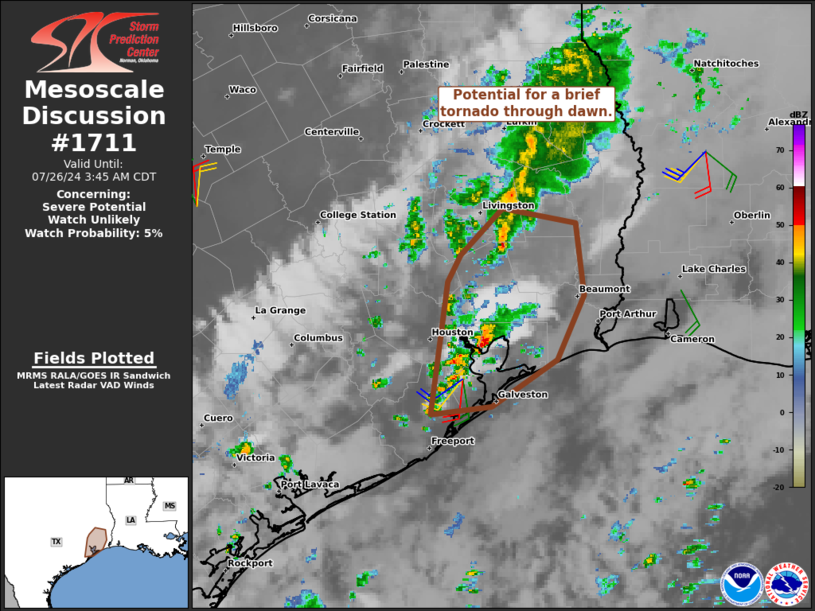
   Mesoscale Discussion 1711
   NWS Storm Prediction Center Norman OK
   0139 AM CDT Fri Jul 26 2024

   Areas affected...Upper TX Coastal Plain

   Concerning...Severe potential...Watch unlikely

   Valid 260639Z - 260845Z

   Probability of Watch Issuance...5 percent

   SUMMARY...Potential exists for a brief tornado through about dawn
   with slow-moving, isolated thunderstorms over the Upper Texas Gulf
   Coastal Plain. The limited spatiotemporal extent and low probability
   of occurrence should preclude a watch issuance.

   DISCUSSION...Persistent low-level warm theta-e advection has
   supported scattered low-topped convection from the Mid to Upper TX
   Gulf Coast into southeast TX. One cell near the north end of
   Galveston Bay has recently deepened into a slow-moving thunderstorm,
   drifting northeast at 10 kts. HGX VWP has sampled 0-1 km shear
   around 20 kts with surface southeasterlies veering to the south at 1
   km. The enhancement to hodograph curvature is nearly exclusively in
   the low-levels, with a nearly unidirectional southwesterly wind
   profile above 2 km. As such, transient supercell structure may
   occur. This would seemingly be most probable within this portion of
   the warm-advection regime given a relatively larger thermal
   gradient, inferred by surface temperatures in the low 80s over
   Galveston Island to low to mid 70s with northern extent in southeast
   TX. The concern in this scenario is if the transient supercell
   structure can briefly intensify to produce a tornado, although a
   downburst or two is also possible. With time, enhanced low-level
   flow should subside/shift northward, and likely curtail the threat
   after daybreak.

   See WPC MPD 0731 for information on the heavy rain/flash flooding
   potential.

   ..Grams/Guyer.. 07/26/2024

   ...Please see www.spc.noaa.gov for graphic product...

   ATTN...WFO...LCH...HGX...

   LAT...LON   30399509 30739474 30639410 30099403 29619426 29269482
               29209534 30199520 30399509
|
|
Top/All Mesoscale Discussions/Forecast Products/Home
|
|


 @NWSSPC