|
| Mesoscale Discussion 1696 |
|
< Previous MD Next MD >
|
|
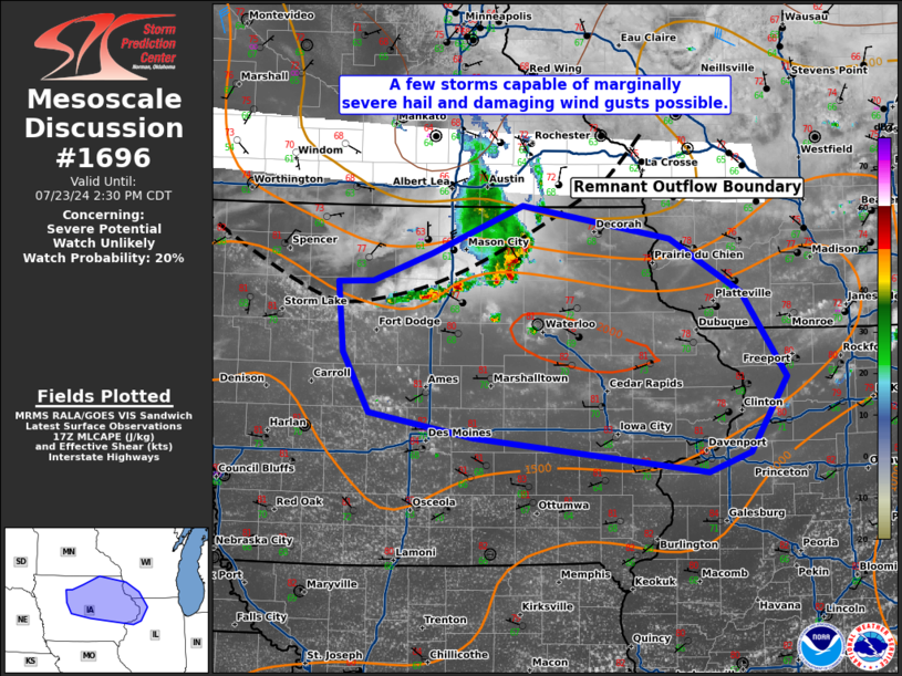
   Mesoscale Discussion 1696
   NWS Storm Prediction Center Norman OK
   1256 PM CDT Tue Jul 23 2024

   Areas affected...central/eastern Iowa...southwest Wisconsin...and
   northwest Illinois

   Concerning...Severe potential...Watch unlikely

   Valid 231756Z - 231930Z

   Probability of Watch Issuance...20 percent

   SUMMARY...A few storms capable of marginally severe hail and
   damaging wind gusts are possible this afternoon/evening across
   eastern Iowa into southwest Wisconsin and northwest Illinois.

   DISCUSSION...Thunderstorms have developed along the outflow boundary
   on the western edge of ongoing thunderstorm activity from this
   morning. These storms, and additional development which has begun
   ahead of this activity will likely congeal into a cluster and move
   east this afternoon, despite each run of the HRRR suggesting its
   demise. This expected cluster will move through through an area with
   1500-2000 J/kg MLCAPE and 20-25 knots of effective shear, which
   should support some marginally large hail and damaging wind gusts
   from this cluster of storms. Despite some obstruction from wildfire
   smoke ahead of these storms, additional heating into the mid 80s is
   expected which should maintain these storms into the evening. Once
   boundary layer cooling begins in earnest, expect the severe weather
   threat to decrease. Due to the somewhat marginal and isolated severe
   weather threat expected, no watch is anticipated.

   ..Bentley/Smith.. 07/23/2024

   ...Please see www.spc.noaa.gov for graphic product...

   ATTN...WFO...LOT...MKX...DVN...ARX...DMX...

   LAT...LON   42899421 43119355 43509257 43239095 42799016 42108967
               41499007 41339054 41619309 41819423 42309453 42889458
               42899421
|
|
Top/All Mesoscale Discussions/Forecast Products/Home
|
|


 @NWSSPC