|
| Mesoscale Discussion 1686 |
|
< Previous MD Next MD >
|
|
Mesoscale Discussion 1686
NWS Storm Prediction Center Norman OK
0105 PM CDT Sat Jul 20 2024
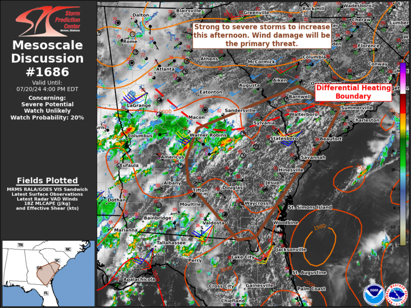
Areas affected...Southeastern Georgia into southern South Carolina
Concerning...Severe potential...Watch unlikely
Valid 201805Z - 202000Z
Probability of Watch Issuance...20 percent
SUMMARY...Storms will intensify along a differential heating
boundary and along the sea breeze. Isolated damaging winds are the
primary hazard. Should clustering occur a locally greater wind
damage threat would be possible. A small severe thunderstorm watch
would be considered if that occurs.
DISCUSSION...Though cloud cover has generally eroded across northern
Georgia/Upstate South Carolina, temperatures have remained cooler in
those locations thus far. This has set up a differential heating
boundary from central Georgia into southern South Carolina. Cumulus
development is ongoing along this boundary as well as the sea
breeze. Thunderstorms have already initiated in central/east-central
Georgia and have been deepening over the last hour per MRMS CAPPI
data. The observed morning sounding from Charleston showed modestly
steeper mid-level lapse rates than other regional soundings (6-6.5
C/km). Portions of southeast Georgia into southern South Carolina
should have some of the better overlap of buoyancy and effective
shear given the enhanced mid-level winds over the region. As storms
continue to deepen/intensify with continued heating, the expectation
is for marginally organized multicells to be capable of sporadic
wind damage. Should clustering occur, a locally greater wind damage
threat would be possible.
..Wendt/Smith.. 07/20/2024
...Please see www.spc.noaa.gov for graphic product...
ATTN...WFO...CHS...CAE...JAX...FFC...TAE...
LAT...LON 32128363 32698339 33508112 33058019 32418060 31778120
31248161 30638209 30588247 31688358 32128363
|
|
Top/All Mesoscale Discussions/Forecast Products/Home
|
|


 @NWSSPC