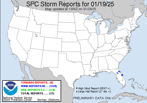
| Tornado Reports (CSV) (Raw Tornado CSV)(?) |
|---|
| No reports received |
| Hail Reports (CSV) (Raw Hail CSV)(?) |
|---|
Time | Size | Location | County | State | Lat | Lon | Comments |
| 1824 | 100 | 1 E Canaveral Acres | Brevard | FL | 2841 | 8082 | An NWS employee measured one inch hail near I-95 and SR-528. (MLB) |
| 1830 | 100 | 3 NE Cocoa | Brevard | FL | 2841 | 8071 | A member of the public reported hail up to an inch in the Merritt Island area. (MLB) |
| 1830 | 100 | 4 NNE Cocoa | Brevard | FL | 2843 | 8071 | A member of the public reported 1 inch hail in the Merritt Island area. (MLB) |
| Wind Reports (CSV) (Raw Wind CSV)(?) |
|---|
Time | Speed | Location | County | State | Lat | Lon | Comments |
| 1201 | UNK | 2 NNE Orange Mills | Putnam | FL | 2971 | 8156 | Putnam County Emergency Management reports downed trees ... a damaged shed ... and damage to a residents porch along Federal Point Road in East Palatka. Time of damage ba (JAX) |
| 1202 | UNK | 2 W Hastings | Putnam | FL | 2971 | 8154 | Delayed report - Public report of damaging wind gusts that damaged a mobile home ... downed trees ... damaged out buildings and a well head. Time of damage based on radar (JAX) |
| 1205 | UNK | 1 NNW Hastings | St. Johns | FL | 2973 | 8151 | St. Johns County Fire/Rescue reports a tree downed on a home due to strong wind gusts ... along with damage to trees and power lines in the vicinity of Hastings. Time of (JAX) |
| 1215 | UNK | 1 W Reddick | Marion | FL | 2937 | 8222 | A few reports of trees down near Northwest 152nd Lane and around 11000 block of Northwest 60th Avenue. Time estimated from radar. (JAX) |
| 1233 | 65 | 3 S Burbank | Marion | FL | 2924 | 8200 | 65 mph wind gust reported near NW 62nd Ave and NW 53rd Street Rd in Ocala. (JAX) |
| 1310 | UNK | 2 SW Palm Coast | Flagler | FL | 2955 | 8124 | Delayed report of several small trees and large branches down near Belle Terre Pkwy in Palm Coast. Time estimated. (JAX) |
| 1315 | UNK | 1 N Flagler Beach | Flagler | FL | 2948 | 8113 | Corrects previous tstm wnd dmg report from 1 N Flagler Beach. Large sign knocked over/damaged in Flagler Beach. Several gusts between 45 and 52 mph were also measured i (JAX) |
| 1320 | UNK | 1 N Flagler Beach | Flagler | FL | 2948 | 8113 | Large sign knocked over/damaged in Flagler Beach. Several gusts between 45 and 52 mph were also measured in the area. Time estimated. (JAX) |
| 1815 | UNK | 3 WSW Cocoa | Brevard | FL | 2836 | 8080 | [Delayed Report] Wind damage reported at Maplewood Village Mobile Home Park. Some homes had carports ripped off and siding damage. (MLB) |
| 1824 | 60 | 1 E Canaveral Acres | Brevard | FL | 2841 | 8082 | An NWS employee reported 60 MPH winds near I-95 and SR-528. (MLB) |
| 1840 | 58 | 8 NNE Cocoa Beach | Brevard | FL | 2843 | 8057 | USSF wind sensor on tower 1 measured a wind gust of 58MPH/50KT from the west on January 19 at 1:40 PM ET. Sensor elevation is 54 feet. (MLB) |
| 1840 | 66 | 9 NNE Cocoa Beach | Brevard | FL | 2846 | 8057 | USSF wind sensor on tower 303 measured a wind gust of 66MPH/57KT from the west on January 19 at 1:40 PM ET. Sensor elevation is 54 feet. (MLB) |
| 1840 | 58 | 10 NNE Cocoa Beach | Brevard | FL | 2847 | 8057 | [Delayed Report] The AWOS at the Cape Canaveral Space Force Station Skid Strip (KXMR) measured a wind gust of 58MPH/50KTS from the west-southwest. (MLB) |
| 1845 | 59 | 11 NE Cocoa Beach | Brevard | FL | 2846 | 8053 | USSF wind sensor on tower 3 measured a wind gust of 59MPH/51KT from the west on January 19 at 1:45 PM ET. Sensor elevation is 54 feet. (MLB) |


 @NWSSPC