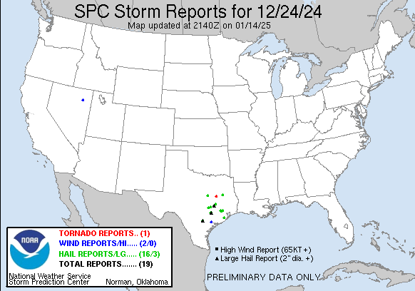
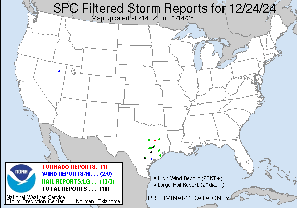
| Tornado Reports (CSV) (Raw Tornado CSV)(?) |
|---|
Time | | Location | County | State | Lat | Lon | Comments |
| 2332 | | 6 S Teague | Freestone | TX | 3153 | 9628 | A brief tornado formed in southwest Freestone County ... just west of the Freestone Community. The tornado traveled a distance of approximately one half mile ... and prim (FWD) |
| Hail Reports (CSV) (Raw Hail CSV)(?) |
|---|
Time | Size | Location | County | State | Lat | Lon | Comments |
| 2120 | 125 | 1 WSW Cypress | Harris | TX | 2997 | 9569 | Corrects previous hail report from 7 ESE Waller. Reports of 1 inch to 1.25 inches of hail near Cypress ... TX. Reports received via social media. (HGX) |
| 2130 | 150 | 3 WSW Cypress | Harris | TX | 2995 | 9572 | (HGX) |
| 2130 | 125 | 7 ESE Waller | Harris | TX | 3000 | 9582 | Reports of 1 inch to 1.25 inches of hail near Cypress ... TX. Reports received via social media. (HGX) |
| 2230 | 100 | 7 SW Gholson | McLennan | TX | 3165 | 9733 | (FWD) |
| 0025 | 175 | 9 NE Elkhart | Anderson | TX | 3169 | 9545 | Corrects previous hail report from 9 NE Elkhart. Delayed report. Public report and photos showed ping pong to golf ball size hail fell around 625pm. (FWD) |
| 0031 | 125 | 3 NE Elgin | Bastrop | TX | 3038 | 9733 | 1.25 inch hail reported by CoCoRaHS spotter. (EWX) |
| 0055 | 200 | 7 NE Caldwell | Burleson | TX | 3060 | 9661 | Corrects previous hail report from 7 NE Caldwell. Public report of 1.5-2 inch hail in Cooks Point from KBTX media - photos indicate hail measuring 2 inches. (HGX) |
| 0115 | 175 | 9 NE Elkhart | Anderson | TX | 3169 | 9545 | Delayed report. Public report and photos showed ping pong to golf ball size hail fell around 715pm. (FWD) |
| 0141 | 125 | Lexington | Lee | TX | 3042 | 9701 | (EWX) |
| 0145 | 100 | 2 NW UR089 | Brazos | TX | 3073 | 9643 | Public report of quarter sized hail at FM 2818 and Highway 6 from KBTX media. (HGX) |
| 0206 | 100 | Lexington | Lee | TX | 3042 | 9701 | (EWX) |
| 0400 | 250 | Falls City | Karnes | TX | 2898 | 9802 | Social media picture of 2.5 inch hail. (EWX) |
| 0426 | 175 | Muldoon | Fayette | TX | 2982 | 9707 | Time estimated by radar. (EWX) |
| 0438 | 275 | 5 E Muldoon | Fayette | TX | 2981 | 9698 | Baseball hail reported on FM 609 between Mach Road and Black Jack Lane. Time estimated by radar. (EWX) |
| 0710 | 100 | 4 SE Tomball | Harris | TX | 3005 | 9556 | Report of 1 inch hail near Tomball. (HGX) |
| 0740 | 150 | Danbury | Brazoria | TX | 2923 | 9535 | Social media video showing large hail in Danbury. Size is estimated by video ... and time estimated by radar. (HGX) |
| Wind Reports (CSV) (Raw Wind CSV)(?) |
|---|
Time | Speed | Location | County | State | Lat | Lon | Comments |
| 0603 | 65 | 5 SW Ruby Valley | Elko | NV | 4073 | 11525 | Station (RBVN2) Ruby Valley ... Elevation 6891 ft. (LKN) |
| 0730 | 58 | 1 E Victoria | Victoria | TX | 2882 | 9696 | 50 knot wind gust measured on a CWOP station. (CRP) |


 @NWSSPC