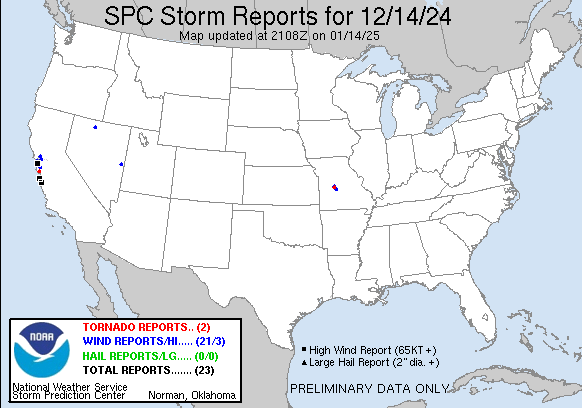
| Tornado Reports (CSV) (Raw Tornado CSV)(?) |
|---|
Time | | Location | County | State | Lat | Lon | Comments |
| 2140 | | 1 SW Scotts Valley | Santa Cruz | CA | 3705 | 12202 | Social media reports of cars overturned and tree damage in and across Scotts Valley. Also video evidence of a tornado. Time estimated via radar. (MTR) |
| 2141 | | 1 NNW Zora | Benton | MO | 3830 | 9310 | NWS storm survey determined that an EF0 tornado damaged trees and an outbuilding along a 1.7 mile long path near Zora ... MO. Maximum winds were estimated at 80 mph with (SGF) |
| Hail Reports (CSV) (Raw Hail CSV)(?) |
|---|
| No reports received |
| Wind Reports (CSV) (Raw Wind CSV)(?) |
|---|
Time | Speed | Location | County | State | Lat | Lon | Comments |
| 1353 | 59 | 3 S Oakland | Alameda | CA | 3773 | 12222 | 59 mph wind gust measured at San Francisco Bay Oakland International Airport (KOAK) associated with band of showers and embedded thunderstorms. (MTR) |
| 1359 | UNK | 3 S San Francisco | San Francisco | CA | 3773 | 12242 | Roof blown off of a structure. Structure type is unknown. Time estimated via radar. (MTR) |
| 1359 | UNK | 1 SSE San Francisco | San Francisco | CA | 3776 | 12241 | Report of tree split at the base at 18th and Treat Street in San Francisco. Time estimated via radar. (MTR) |
| 1359 | UNK | 4 W San Francisco | San Francisco | CA | 3777 | 12250 | Report relayed via social media showing numerous trees uprooted or snapped in the Bison Paddock region of Golden Gate Park. Time estimated via radar. (MTR) |
| 1359 | UNK | 3 W San Francisco | San Francisco | CA | 3778 | 12247 | Video report of a large tree branch blocking a portion of a road in the Richmond District (northern San Francisco). Report relayed via social media. Time estimated via (MTR) |
| 1359 | UNK | 4 W San Francisco | San Francisco | CA | 3778 | 12249 | Multiple trees and tree branches down near 28th Ave and Geary Boulevard. (MTR) |
| 1400 | UNK | 2 SSE San Francisco | San Francisco | CA | 3774 | 12241 | Report of a large tree down on powerlines. (MTR) |
| 1400 | UNK | 5 W San Francisco | San Francisco | CA | 3776 | 12250 | Delayed report via social media showing damage to fence and tree down on car. (MTR) |
| 1409 | 83 | 2 NE Millbrae | San Mateo | CA | 3762 | 12238 | Peak wind gust of 72 knots or 83 mph measured at San Francisco International Airport just after 6 AM. (MTR) |
| 1426 | UNK | 1 E Millbrae | San Mateo | CA | 3760 | 12238 | Tree blocking the onramp from East Millbrae Ave to Southbound US Highway 101. (MTR) |
| 1450 | UNK | 4 SSE Napa | Napa | CA | 3825 | 12227 | Large tree branch blocking southbound State Route 221 at Napa Valley Corporate Way. (MTR) |
| 1456 | UNK | 1 S Millbrae | San Mateo | CA | 3758 | 12240 | Large tree down on southbound Interstate 280 south of Trousdale Drive. (MTR) |
| 1500 | 78 | 1 WSW Del Rey Oaks | Monterey | CA | 3659 | 12185 | Monterey Peninsula Airport reported a 78 mph wind gust. (MTR) |
| 1500 | UNK | 2 NNE Del Monte Forest | Monterey | CA | 3661 | 12193 | Report relayed via broadcast media of tree branch puncturing the roof of a structure. Report time is coincident with line of showers and embedded thunderstorms moving a (MTR) |
| 1520 | UNK | 2 ESE Mountain View | Santa Clara | CA | 3739 | 12205 | Tree down blocking all lanes of Eastbound State Route 237 at Middlefield. (MTR) |
| 1546 | 76 | 15 SE Carmel Valley Vil | Monterey | CA | 3631 | 12157 | Remote Automated Weather System (RAWS) reported +60mph wind gusts between 646am and 846am. Peak wind gust was 76 mph at 7:46 am. (MTR) |
| 1805 | UNK | 1 NW Martinez | Contra Costa | CA | 3801 | 12212 | Report from mPING: 1-inch tree limbs broken; Shingles blown off damage category. (MTR) |
| 2142 | UNK | 1 N Zora | Benton | MO | 3831 | 9309 | Spotter photos and videos indicate several large trees uprooted and large branches snapped ... as well as a barn made of sheet metal ripped apart and thrown into nearby (SGF) |
| 2210 | UNK | 4 SE Barnumton | Camden | MO | 3807 | 9289 | Time estimated by radar. Emergency management reported damage to a dock structure on Ski Valley Drive in the Roach area. (SGF) |
| 2211 | 69 | 2 ENE Wheeler Peak Snot | White Pine | NV | 3902 | 11427 | Station (MTHN2) Mather ... Elevation 9268 ft. (LKN) |
| 0637 | 59 | 4 S Lamance Creek Snote | Humboldt | NV | 4145 | 11762 | Station (MORN2) Morey Creek ... Elevation 5500 ft. (LKN) |