Probability of damaging thunderstorm winds or wind gusts of 50 knots or higher within 25 miles of a point. Hatched Area: 10% of greater probability of wind gusts 65 knots or greater within 25 miles of a point.
Lubbock, TX...Shreveport, LA...Little Rock, AR...Waco, TX...Abilene, TX...
SPC AC 270100
Day 1 Convective Outlook
NWS Storm Prediction Center Norman OK
0800 PM CDT Sat Apr 26 2025
Valid 270100Z - 271200Z
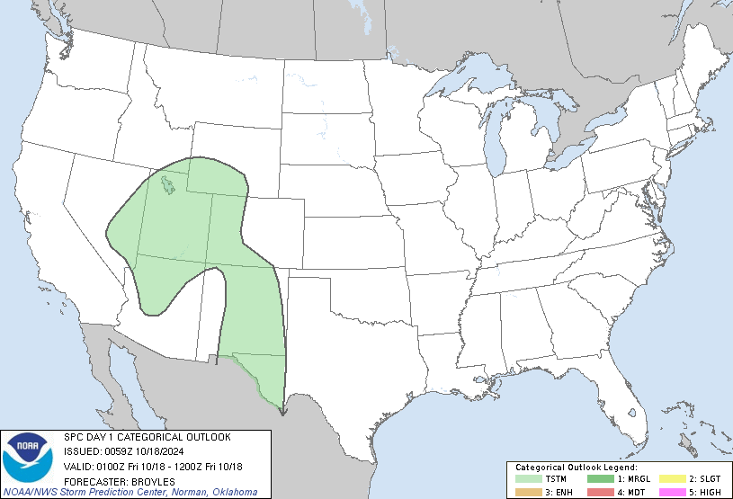
...THERE IS A SLIGHT RISK OF SEVERE THUNDERSTORMS FOR PARTS OF
EASTERN NM INTO SOUTHWEST TX...AND ALSO NEAR THE ARKLATEX
VICINITY...
...SUMMARY...
Scattered severe thunderstorms may continue over eastern New Mexico
into parts of west Texas through the evening. A threat for large to
very large hail and a couple of tornadoes are the primary risks.
Scattered strong to severe storms also remain possible across parts
of western/central Arkansas and vicinity.
...Eastern NM into west/central TX...
Widely scattered supercells are ongoing this evening from
east-central NM into the TX Permian Basin region, near and to the
south of a remnant outflow boundary that earlier moved into the
region from the east. MLCINH will increase through the evening
across the region, and the eastward advance of the NM storms may be
limited by a less unstable and increasingly capped airmass to the
cool side of the remnant outflow. However, a modest increase in
low-level flow through the evening may help to maintain a couple of
these supercells, which will tend to propagate southeastward along
the instability gradient. Backed low-level flow and modestly
enlarged hodographs may continue to support tornado potential with
these cells for as long as they persist and remain surface-based.
Otherwise, large to very large hail and localized severe gusts will
remain a threat with the strongest storms.
Farther east, an isolated strong storm or two may yet develop within
a persistent cumulus field across parts of central TX. Moderate
instability and deep-layer shear could support at least briefly
organized storms if initiation occurs, with a threat of isolated
hail and strong gusts.
...Western/central AR and vicinity...
Moderate instability and modestly enhanced midlevel flow attendant
to an MCV over eastern OK have supported occasional supercell
structures early this evening from western AR into the ArkLaTex
region. A few stronger cells may persist through dusk, accompanied
by a threat of hail, isolated damaging wind, and possibly a tornado
or two. A gradual weakening trend is expected later this evening
after the onset of nocturnal cooling, though relatively rich
low-level moisture may delay this process somewhat and allow for
some severe threat to spread into parts of central AR with time.
...Parts of the Carolinas/southeast VA...
Widely scattered storms are ongoing this evening from the eastern
Carolinas into southeast VA, along/ahead of a cold front. MLCAPE
around 1000 J/kg and modest deep-layer shear could support
occasionally strong storms with potential for locally gusty/damaging
winds, before storms weaken later this evening.
..Dean.. 04/27/2025
NOTE: THE NEXT DAY 1 OUTLOOK IS SCHEDULED BY 0600Z